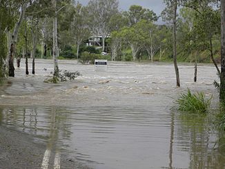
Calliope River
| Calliope River | ||
|
Flood on the Calliope River in December 2010 |
||
| Data | ||
| location | Queensland , Australia | |
| River system | Calliope River | |
| source | in the Calliope Range 23 ° 57 ′ 57 ″ S , 150 ° 41 ′ 53 ″ E |
|
| Source height | 182 m | |
| muzzle | at Gladstone in the Pacific Coordinates: 23 ° 49 ′ 16 ″ S , 151 ° 13 ′ 5 ″ E 23 ° 49 ′ 16 ″ S , 151 ° 13 ′ 5 ″ E |
|
| Mouth height | 0 m | |
| Height difference | 182 m | |
| Bottom slope | 1.9 ‰ | |
| length | 98 km | |
| Catchment area | 2241 km² | |
| Left tributaries | Gravel, Larcom, Harper, Alma Creek | |
| Right tributaries | Double, Sheep, Oaky, Lost Spring Creek | |
| Medium-sized cities | Gladstone | |
The Calliope River is an Australian river in central Queensland .
It rises in the Calliope Range west of the industrial and port city of Gladstone , flows north past the town of Calliope and flows into the Pacific Ocean in the north of Gladstone . Its length is 98 kilometers, the catchment area around 2,241 square kilometers.
The most important line of business in the river basin is livestock.
See also
Web links
Commons : Calliope River - collection of images, videos and audio files
- Calliope River catchment
- Map of the catchment area of the Calliope River (pdf; 142 kB)
- Calliope River Basin Summary (pdf; 470 kB)
- Panoramio photo
