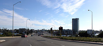
Canning Highway
| Canning Highway | |||||||||||||||||||||||||||||||||||||||||||||||||||||||
|---|---|---|---|---|---|---|---|---|---|---|---|---|---|---|---|---|---|---|---|---|---|---|---|---|---|---|---|---|---|---|---|---|---|---|---|---|---|---|---|---|---|---|---|---|---|---|---|---|---|---|---|---|---|---|---|
 
|
|||||||||||||||||||||||||||||||||||||||||||||||||||||||
| Basic data | |||||||||||||||||||||||||||||||||||||||||||||||||||||||
| Operator: | Main Roads | ||||||||||||||||||||||||||||||||||||||||||||||||||||||
| Start of the street: |
|
||||||||||||||||||||||||||||||||||||||||||||||||||||||
| End of street: |
Fremantle ( WA ) ( 32 ° 3 ′ S , 115 ° 45 ′ E ) |
||||||||||||||||||||||||||||||||||||||||||||||||||||||
| Overall length: | 17 km | ||||||||||||||||||||||||||||||||||||||||||||||||||||||
|
States : |
|||||||||||||||||||||||||||||||||||||||||||||||||||||||
| North Bridge over the Canning River | |||||||||||||||||||||||||||||||||||||||||||||||||||||||
|
Course of the road
|
|||||||||||||||||||||||||||||||||||||||||||||||||||||||
The Canning Highway is a major road in Perth in the southeast of the Australian state of Western Australia . It connects the Great Eastern Highway and the Albany Highway in the Victoria Park district with the port city of Fremantle .
Most of the road has four lanes and a speed limit of 60 km / h over its entire length. It accompanies the Swan River on its south bank between the Causeway (S5) in Victoria Park and Queen Victoria Street (S12) in Fremantle.
history
The Canning Highway was named after Alfred Canning , one of the first pastoralists in Western Australia, who settled in what is now the Local Government Area of Melville City in the late 19th century .
Work on the modern highway began in the 1920s. Construction began in 1927 with the expansion of the 8 km long section between Suburban Street in South Perth and Petra Street in East Fremantle . Initially, the street had the following names:
- Canning Road (Fremantle-Wireless Hill)
- Perth – Fremantle Road (Wireless Hill – Canning Bridge)
- Lower Canning Road (Canning Bridge – South Terrace)
- Fremantle Road (South Terrace – Causeway)
On November 23, 1937, the street was officially renamed the Canning Highway. In 1938, today's north bridge was opened over the Canning River . It was 9.8 m wide and made of wood, as was common at the time. The experience gained during construction could be used in the construction of the Fremantle Traffic Bridge over the Swan River a year later. This bridge connected the Canning Highway at Fremantle with North Fremantle and now forms the western end of the road.
In 1958, together with the Kwinana Freeway between the Narrows Bridge and the Canning Highway, today's south bridge was built over the Canning River.
In 1974, the roundabout at the southern end of the Causeway in Victoria Park was expanded to a partial clover leaf , so that the Canning Highway was connected to the Great Eastern Highway without intersections. At the same time the Stirling Highway was extended from North Fremantle over the Swan River and the new Sterling Bridge and connected to the Canning Highway.
In 1979 a new height-free intersection with the Kwinana Freeway was built on the north bridge over the Canning River, so that it could be extended to the south under the Canning Highway.
Since then there have only been minor changes to the Canning Highway, such as: B. the cultivation of short additional tracks.
Numbering
The Canning Highway takes over the numbering from the Great Eastern Highway as Route 1 (R1) and passes it on to the Kwinana Freeway.
literature
- Leigh Edmonds: The vital link: a history of Main Roads Western Australia 1926-1996 . University of Western Australia Press, Nedlands, Western Australia 1997, ISBN 1-875560-87-4 .
- StreetSmart Perth 2003 Street Directory . Department of Land Administration and West Australian Newspapers Ltd, Midland, Western Australia 2002, ISBN 0-909699-87-9 .
source
Steve Parish: Australian Touring Atlas . Steve Parish Publishing. Archerfield QLD 2007. ISBN 978-1-74193-232-4 . P. 77
