Swan River (Indian Ocean)
| Swan River | ||
|
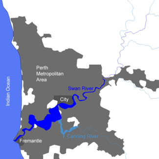
Map of the lower reaches |
||
| Data | ||
| location | Western Australia , Australia | |
| River system | Swan River | |
| Drain over | Swan River → Indian Ocean | |
| source |
Walyunga National Park 31 ° 44 ′ 1 ″ S , 116 ° 4 ′ 29 ″ E |
|
| Source height | 29 m | |
| muzzle | at Fremantle in the Indian Ocean Coordinates: 32 ° 3 ′ 16 ″ S , 115 ° 44 ′ 6 ″ E 32 ° 3 ′ 16 ″ S , 115 ° 44 ′ 6 ″ E |
|
| Mouth height | 0 m | |
| Height difference | 29 m | |
| Bottom slope | 0.42 ‰ | |
| length | 69.8 km | |
| Left tributaries | Wooroloo Brook , Susannah Brook , Jane Brook , Helena River , Canning River | |
| Right tributaries | Bennett Brook | |
| Big cities | Perth | |
|
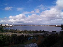
Lower river at Fremantle with the Perth skyline in the background |
||
The Swan River is a river in Western Australia , by the Metropolitan Area Perth flows and about 15 kilometers south-west at Fremantle in the Indian Ocean opens .
Location, geography and landscapes
The Swan River begins in Walyunga National Park , a water-rich eucalyptus forest and bush landscape with granite formations about 50 kilometers northeast of Perth, at the confluence of the Wooroloo Brook in the Avon River . There can be no talk of a confluence of two source rivers; rather, the Swan River is the de facto continuation of the Avon River, which at this point has already covered 210 kilometers since its source in Western Australia's wheat belt . It happens occasionally with Australian rivers that they change their name near the coast.
The Swan River in the narrower sense is around 65 kilometers long to the mouth and flows through the following landscapes:
- About 15 kilometers from the national park and the acacia and banksia bush land adjoining it to the south , which is outside the national park;
- In another 20 kilometers of its upper reaches this as a wine region known Swan Valley , which on the territory of the City of Swan the northeastern periphery of the metropolitan area ( metropolitan area ) Perth constituted. There is a strip of scrubland immediately along the river; to the west and east of it the vineyards spread out, broken through by settlements and wineries. The urban character of the country increases further downstream.
- The historic town of Guildford is the southern limit of the Swan Valley wine region; Another 15 kilometers the river runs through the suburbs of Perth, which constitute independent administrative units, until it reaches the center of Perth on Riverside Drive. On this route, the Swan River flows past residential areas, golf courses and horse racing tracks.
- Along the inner city of Perth it spreads to a first lake, the Perth Water. Then the course narrows again at the Narrows Bridge , which was built as a haunched cantilever bridge according to the design of the architect EWH Gilford in 1959. It has a total length of 396.5 meters.
- South of the Narrows Bridge the lower course of the river begins for 15 kilometers to Fremantle, the very wide Melville Water with a lake-like character. In contrast to the upper course, which can only partially be used by small excursion boats, the lower course is fully navigable. After the Narrows Bridge , the Perth Botanical Gardens ( Kings Park ) extend on the north bank , much of which is natural bushland. The tributary Canning River flows into the lake from the south . It is followed on both sides of the lake by the western suburbs of Perth with extensive marinas and promenades.
- In its last three kilometers, the water narrows again to a regulated river, which merges into the inner harbor basin of Fremantle , the largest port in Western Australia on the Indian Ocean.
Tributaries with mouth heights
- Wooroloo Brook - 29 m
- Susannah Brook - 14 m
- Jane Brook - 8 m
- Helena River - 3 m
- Bennett Brook - 2 m
- Canning River - 1 m
history
A mythical beings from the Dreamtime of Noongar - Aborigines , the snake wagyl , formed the Swan River, the Canning River and other waterways and landscapes in the southwest of Western Australia.
The Dutch explorer Willem de Vlamingh was the first European to sail on the river in 1697. He already registered the famous black swans to which the river owes its name and Western Australia the heraldic animal . In the 21st century, these swans, which can be seen irregularly in larger or smaller numbers at different points on the river, are a tourist attraction on promenades and boat trips.
De Vlamingh only got as far as Heirisson Island , level with what is now Perth city center. A French expedition under Nicholas Baudin sailed further up the river in 1801.
The land on either side of the river was first discovered by James Stirling in 1827 and conquered for Great Britain in 1829 as the Swan River Colony . Stirling founded the three settlements Fremantle, Perth and Guildford as the urban nucleus of the colony.
The first vines in the Swan Valley are believed to have been planted between 1830 and 1836. The rise of the wine region to the most famous in Western Australia took place in the 20th century.
Before the Perth-Fremantle railroad was built, the Swan River was the main route. Because of the muddy subsoil, only flat boats could operate on the water. A limestone reef and sank banks originally blocked the river's mouth in the Indian Ocean; they had to be removed in 1891 to make the port usable for shipping.
Problematic environmental conditions prevailed on the lower reaches of the Swan River until the 1970s. Fertilizers and industrial wastewater were discharged untreated. The consequence was regular fish deaths due to algae growth in summer. In the 21st century, water quality has improved thanks to regulatory measures to protect water bodies.
Walyunga National Park was established in 1970 to protect the natural landscape on the upper reaches of the river.
Tourism has been a thriving industry on the Swan River since the late 20th century.
literature
- Seddon, George: Swan River Landscapes , University of Western Australia, Printing Press, 1970


