Great Eastern Highway
| Great Eastern Highway | |||||||||||||||||||||||||||||||||||||||||||||||||||||||||||||||||||||||||||||||||||||||||||||||||||||||||||||||||||||||||||||||||||||||||||
|---|---|---|---|---|---|---|---|---|---|---|---|---|---|---|---|---|---|---|---|---|---|---|---|---|---|---|---|---|---|---|---|---|---|---|---|---|---|---|---|---|---|---|---|---|---|---|---|---|---|---|---|---|---|---|---|---|---|---|---|---|---|---|---|---|---|---|---|---|---|---|---|---|---|---|---|---|---|---|---|---|---|---|---|---|---|---|---|---|---|---|---|---|---|---|---|---|---|---|---|---|---|---|---|---|---|---|---|---|---|---|---|---|---|---|---|---|---|---|---|---|---|---|---|---|---|---|---|---|---|---|---|---|---|---|---|---|---|---|---|
  94 
|
|||||||||||||||||||||||||||||||||||||||||||||||||||||||||||||||||||||||||||||||||||||||||||||||||||||||||||||||||||||||||||||||||||||||||||
| map | |||||||||||||||||||||||||||||||||||||||||||||||||||||||||||||||||||||||||||||||||||||||||||||||||||||||||||||||||||||||||||||||||||||||||||
| Basic data | |||||||||||||||||||||||||||||||||||||||||||||||||||||||||||||||||||||||||||||||||||||||||||||||||||||||||||||||||||||||||||||||||||||||||||
| Operator: | Main Roads | ||||||||||||||||||||||||||||||||||||||||||||||||||||||||||||||||||||||||||||||||||||||||||||||||||||||||||||||||||||||||||||||||||||||||||
| Start of the street: |
|
||||||||||||||||||||||||||||||||||||||||||||||||||||||||||||||||||||||||||||||||||||||||||||||||||||||||||||||||||||||||||||||||||||||||||
| End of street: |
94 / Goldfields Highway Kalgoorlie ( WA ) ( 30 ° 45 ′ S , 121 ° 29 ′ E ) |
||||||||||||||||||||||||||||||||||||||||||||||||||||||||||||||||||||||||||||||||||||||||||||||||||||||||||||||||||||||||||||||||||||||||||
| Overall length: | 573 km | ||||||||||||||||||||||||||||||||||||||||||||||||||||||||||||||||||||||||||||||||||||||||||||||||||||||||||||||||||||||||||||||||||||||||||
|
States : |
|||||||||||||||||||||||||||||||||||||||||||||||||||||||||||||||||||||||||||||||||||||||||||||||||||||||||||||||||||||||||||||||||||||||||||
| Great Eastern Highway at The Lakes east of Perth | |||||||||||||||||||||||||||||||||||||||||||||||||||||||||||||||||||||||||||||||||||||||||||||||||||||||||||||||||||||||||||||||||||||||||||
|
Course of the road
|
|||||||||||||||||||||||||||||||||||||||||||||||||||||||||||||||||||||||||||||||||||||||||||||||||||||||||||||||||||||||||||||||||||||||||||
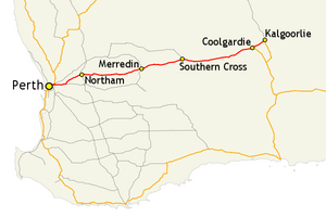
The Great Eastern Highway is a trunk road in the southwest of the Australian state of Western Australia . It connects the state capital Perth with the Goldfields Highway in the gold rush town of Kalgoorlie . It is the main road from Perth to the Eastern Wheatbelt Region and the Eastern Goldfields region .
course
The Great Eastern Highway begins in Victoria Park , an eastern borough of Perth. There it begins at the junction of the Canning Highway (R1 / S6), which runs from Fremantle to Victoria Park, the Causeway (S5), which runs from Perth city center over the Swan River , and the Albany Highway (S30), which runs in the city of the same name leads. The highway initially leads through the densely populated inner districts of Perth, where it is mainly used by commuters and rush hour traffic. In the outer districts of the metropolis of Perth, which stretch to Mundaring , approx. 35 km northeast of Perth city center, traffic is decreasing. The highway there is also less well developed, but due to the advancing urbanization of the area there are constant expansion measures on the highway.
The Great Southern Highway (S120) branches off at the town of The Lakes . This first leads east and later turns south and leads to Albany on the south coast. The Great Eastern Highway then leads about 50 km northeast to Northam . It is the largest inland city in Western Australia that was not founded as a mining town.
Behind Northam, the Great Eastern Highway begins its way east through the Wheatbelt region of Western Australia. The highway passes several cities and small towns such as Meckering, Cunderin, Kellerberrin, Merredin and Southern Cross . All of these places were founded during the gold rush in the 1890s and served as stops for the prospectors on their way to Coolgardie and Kalgoorlie.
With Coolgardie you have reached the first of the famous gold rush towns. The city flourished after the first gold discoveries in 1892 by Arthur Bayley and William Ford , who were the first to find 15.7 kg of gold . After almost becoming a ghost town after a few years , it is now a popular destination for tourists again. In Coolgardie, the Coolgardie-Esperance Highway (N94) branches off to the south. The Great Eastern Highway continues northeast for another 40 km until it reaches Kalgoorlie, where it meets and ends with the Goldfields Highway (R94 / ALT94). In this area it is numbered R94. The history of Kalgoorlie is similar to that of Coolgardies, but the decline in population and importance has never been so dramatic, as Kalgoorlie is closer to the gold fields and is still the supply center for the nearby open-cast mine to this day .
numbering
-
 from Victoria Park ( Perth ) to the junction of the Great Northern Highway in Midland (Perth)
 -
 from the junction of the Great Northern Highway in Midland ( Perth ) to the junction with the Roe Highway in Midvale (Perth)
 -
 from Victoria Park ( Perth ) to the junction of the Great Eastern Highway Bypass in Ascot (Perth) and from the junction with the Roe Highway in Midvale (Perth) to the junction of the Coolgardie-Esperance Highway in Coolgardie
- 94 from the junction of theCoolgardie-Esperance HighwayinCoolgardietoKalgoorlie
source
Steve Parish: Australian Touring Atlas . Steve Parish Publishing. Archerfield QLD 2007. ISBN 978-1-74193-232-4 . Pp. 82 + 83
Individual evidence
- ↑ see also: Clackline Bridge

