Albany Highway
| Albany Highway | ||||||||||||||||||||||||||||||||||||||||||||||||||||||||||||||||||||||||||||||||||||||||||||||||||||||||||||||||||||||||||||||||||||||||||||||
|---|---|---|---|---|---|---|---|---|---|---|---|---|---|---|---|---|---|---|---|---|---|---|---|---|---|---|---|---|---|---|---|---|---|---|---|---|---|---|---|---|---|---|---|---|---|---|---|---|---|---|---|---|---|---|---|---|---|---|---|---|---|---|---|---|---|---|---|---|---|---|---|---|---|---|---|---|---|---|---|---|---|---|---|---|---|---|---|---|---|---|---|---|---|---|---|---|---|---|---|---|---|---|---|---|---|---|---|---|---|---|---|---|---|---|---|---|---|---|---|---|---|---|---|---|---|---|---|---|---|---|---|---|---|---|---|---|---|---|---|---|---|---|

|
||||||||||||||||||||||||||||||||||||||||||||||||||||||||||||||||||||||||||||||||||||||||||||||||||||||||||||||||||||||||||||||||||||||||||||||
| map | ||||||||||||||||||||||||||||||||||||||||||||||||||||||||||||||||||||||||||||||||||||||||||||||||||||||||||||||||||||||||||||||||||||||||||||||
| Basic data | ||||||||||||||||||||||||||||||||||||||||||||||||||||||||||||||||||||||||||||||||||||||||||||||||||||||||||||||||||||||||||||||||||||||||||||||
| Operator: | Main Roads | |||||||||||||||||||||||||||||||||||||||||||||||||||||||||||||||||||||||||||||||||||||||||||||||||||||||||||||||||||||||||||||||||||||||||||||
| Start of the street: |
Victoria Park ( Perth ) ( WA ) ( 31 ° 58 ′ S , 115 ° 53 ′ E ) |
|||||||||||||||||||||||||||||||||||||||||||||||||||||||||||||||||||||||||||||||||||||||||||||||||||||||||||||||||||||||||||||||||||||||||||||
| End of street: |
Middleton Road Albany ( WA ) ( 35 ° 1 ′ S , 117 ° 53 ′ E ) |
|||||||||||||||||||||||||||||||||||||||||||||||||||||||||||||||||||||||||||||||||||||||||||||||||||||||||||||||||||||||||||||||||||||||||||||
| Overall length: | 410 km | |||||||||||||||||||||||||||||||||||||||||||||||||||||||||||||||||||||||||||||||||||||||||||||||||||||||||||||||||||||||||||||||||||||||||||||
|
States : |
||||||||||||||||||||||||||||||||||||||||||||||||||||||||||||||||||||||||||||||||||||||||||||||||||||||||||||||||||||||||||||||||||||||||||||||
| Albany Highway in Cannington | ||||||||||||||||||||||||||||||||||||||||||||||||||||||||||||||||||||||||||||||||||||||||||||||||||||||||||||||||||||||||||||||||||||||||||||||
|
Course of the road
|
||||||||||||||||||||||||||||||||||||||||||||||||||||||||||||||||||||||||||||||||||||||||||||||||||||||||||||||||||||||||||||||||||||||||||||||
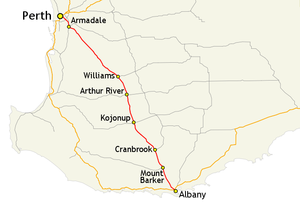
The Albany Highway is a trunk road in the southwest of the Australian state of Western Australia . The highway runs in a northwest-southeast direction and is 410 km long. It connects the state capital Perth with the South Coast Highway in Albany , the oldest settlement in Western Australia on the south coast. The Albany Highway is generally considered to be the border between the South West and the Great Southern Region .
history
The Albany Highway has its origins in 1853 when William Crossman researched and described various possible routes for a road between Perth and Albany. Based on his reports, it was decided to build Albany Road. The construction was initially carried out as a straightening of the site and partially fortified with wooden blocks and limestone paving. The work was carried out by prisoners from the Swan River convict colony .
course
The Albany Highway begins in Perth city center in the Victoria Park neighborhood on the east bank of the Swan River . It begins at the junction with the Canning Highway (N1) coming from Fremantle , the Causeway (S5) coming from downtown Perth and the Great Eastern Highway (N94) leading to Kalgoorlie-Boulder .
Initially, the Albany Highway is a two-lane road that opens up downtown Victoria Park, while through traffic is routed via the nearby and better-developed Shepperton Road. At the junction with Welshpool Road , the Albany Highway becomes a six-lane expressway. Over a length of 26 km, it serves as the main connection road to the south-eastern suburbs of Perth and is therefore mainly characterized by heavy commuter traffic. The traffic situation only eases a little after the Kelmscott district , as the outer suburbs of the Perth metropolitan area have been reached.
In Armadale , where the Albany Highway branches off in a south-easterly direction, the south-leading South Western Highway (S20) begins . As a result, the picture of the landscape is changing noticeably: Settlements along the highway are becoming rarer, instead forests and farmland characterize the landscape. About 130 km behind Armadale Williams is the first major settlement on the highway. Arthur River , Kojonup and Mount Barker follow at intervals of 40-100 km.
At Cranbrook , the Great Southern Highway (S120) meets the Albany Highway from the east . The closer you get to Albany, the more eucalyptus plantations along the road become. Just before Albany, the Albany Highway crosses the South Coast Highway (R1) before ending at the junction with Middleton Road in Albany.
source
Steve Parish: Australian Touring Atlas . Steve Parish Publishing. Archerfield QLD 2007. ISBN 978-1-74193-232-4 . Pp. 78, 79, 81


