Cap-Haïtien
| Cap-Haïtien | ||
|---|---|---|
|
|
||
| Coordinates | 19 ° 46 ′ N , 72 ° 12 ′ W | |
| Basic data | ||
| Country | Haiti | |
| North | ||
| Arrondissement | Cap-Haïtien | |
| ISO 3166-2 | HT-ND | |
| local community | Cap-Haïtien | |
| height | 0 m | |
| Residents | 111.094 (2003) | |
| founding | 1670 | |
|
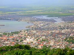
View of Cap-Haïtien
|
||
Cap-Haïtien is a port city on the north coast of the Caribbean island of Hispaniola in Haiti with 111,094 inhabitants (2003 census).
history
Founded as Cap-François in 1670, the city was the capital of the French colony of Saint-Domingue for about a century and the capital of the northern Haitian state from 1806 to 1820 . Today it is the economic center of the region and an important tourist destination.
The Haitian national hero François-Dominique Toussaint L'Ouverture was born in the city in 1743.
On May 7, 1842, the city was largely destroyed by a very strong earthquake , which is said to have killed up to 10,000 people.
Since 1861 the city has been the official seat of the Archdiocese of Cap-Haïtien .
Town twinning
Cap-Haïtien is a sister of the US city of Portland (Maine) .
sons and daughters of the town
- François-Dominique Toussaint L'Ouverture (around 1743–1803), Haitian national hero of African descent, one of the first leaders of the Latin American independence movement
- Jean Antoine Tancrède Auguste (1856–1913), Haitian general, politician and president
- Justin Elie (1883–1931), composer and pianist
- Ernst Jean-Joseph (1948–2020), football player
Web links
Individual evidence
- ↑ Interview with Hans Christoph Buch in Tagesspiegel , accessed on January 18, 2010
- ^ Commentary by Peter Hallward in the Guardian , accessed January 18, 2010
- ↑ Portland website , accessed August 16, 2019


