
Cape Fear River
| Cape Fear River | ||
 Catchment area of the Cape Fear River |
||
| Data | ||
| location | North Carolina , United States | |
| River system | Cape Fear River | |
| muzzle |
Atlantic Ocean Coordinates: 33 ° 53 '8 " N , 78 ° 0' 46" W 33 ° 53 '8 " N , 78 ° 0' 46" W
|
|
| length | 325 km | |
| Drain |
MQ |
110 m³ / s |
| Navigable | to Fayetteville | |
 The Cape Fear River at Smith Creek in Wilmington, NC. |
||
The Cape Fear River is a 325 km long black water river in central eastern North Carolina in the United States . It flows into the Atlantic Ocean at Cape Fear , which gives the river its name. Notropis mekistocholas (English Cape Fear Shiner ) is an endemic species of fish in its catchment area .
Run
The Cape Fear River is formed in Haywood near the county border between Lee County and Chatham County by the confluence of the Deep River and Haw River , directly below the B. Everett Jordan Lake . It flows southeast past Lillington , Fayetteville and Elizabethtown . About 16 km northwest of Wilmington the Black River flows into Wilmington and the Northeast Cape Fear River . It then turns south and flows as an estuary into the Atlantic Ocean, about 5 km west of Cape Fear.
During the colonial era , the river was a major route into interior North Carolina. Today the river is navigable through a series of locks and dams to Fayetteville. The estuary of the Cape Fear River is part of the American Atlantic Intracoastal Waterway .
In Wilmington, the battleship USS North Carolina , which was in service during World War II, lies in the river . It is listed on the National Register of Historic Places and now serves as a museum ship.
When Hurricane Florence approached in September 2018 , all residents along the river were asked to leave their homes temporarily. The hurricane caused meter-high floods; numerous people died and hundreds of thousands of people were without electricity for days. After a dam at a power station broke, toxic coal ash found its way into the river.
See also
Web links
- Cape Fear River discharge values available since 9/1/1969. In: UNCW Coastal Ocean Research and Monitoring Program: Monitoring Stations. Archived from the original on March 5, 2016 .
- Lower Cape Fear River Program. University of North Carolina at Wilmington , archived from the original on February 26, 2009 .
- Center for Marine Science: Aquatic Ecology Laboratory . University of North Carolina at Wilmington (English).
- Benthic Ecology Laboratory . University of North Carolina at Wilmington (English).
- Thomas E. Lankford Jr.: Ichthyology and Fish Ecology Laboratory . University of North Carolina at Wilmington (English).
Individual evidence
- ↑ Cape Fear River. In: The Columbia Gazetteer of North America. Columbia University Press, 2000, archived from the original on April 1, 2005 ; accessed on April 28, 2018 (English).
- ↑ nytimes.com September 21, 2018: Florence's Floodwaters Breach Defenses at Duke Energy Plant, Sending Toxic Coal Ash Into River
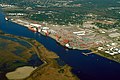
Harbor in Wilmington on the river estuary
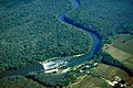
Lock and Dam No. 1 of the Cape Fear River in Bladen County

A cargo ship travels the estuary at Southport

Cargo ship at Southport


