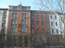
Carusufer
| Carusufer | |
|---|---|
| Street in Dresden | |
| Carus banks as Water Street , 1895 | |
| Basic data | |
| place | Dresden |
| District | Inner New Town |
| Hist. Names | Fürstenweg, Stolpener Straße, An der Elbe, Wasserstraße, Arnimstraße, Admiral-Scheer-Ufer, Reichpietschufer |
| Cross streets | Löwenstrasse, Lessingstrasse, Weintraubenstrasse , Hoyerswerdaer Strasse |
| Places | Rosa-Luxemburg-Platz |
| use | |
| User groups | Motor traffic , pedestrian traffic , bicycle traffic |
Carusufer is an inner-city street in the inner Neustadt of Dresden . It runs on the side of the rose garden facing away from the Elbe to Rosa-Luxemburg-Platz . The name is partly transferred to the section of the Neustädter Elbe bank in front of it. The street is named after the doctor and painter Carl Gustav Carus .
Importance for traffic
The Carusufer runs close to the bank but is flood-proof as a parallel to Melanchthonstrasse and Tieckstrasse through the southeast of Inner Neustadt. Cross connections to Bautzner Straße are (from east to west) the Löwenstraße, Lessingstraße, Weintraubenstraße and Hoyerswerdaer Straße .
The Weintraubenstraße, which opens halfway, directs traffic inwards from Bautzner Straße ( B 6 ) over the Carusufer to Rosa-Luxemburg-Platz, where it is led over the Albertbrücke . Until the start of construction on Rosa-Luxemburg-Platz in summer 2014 as a result of the renovation and widening of the Albert Bridge, there was a directional lane to Wigardstraße (connection at Carolaplatz to Carolabrücke ) and a branch to Glacisstraße of minor importance. Due to the traffic routing at Rosa-Luxemburg-Platz, only the Albertbrücke - Hoyerswerdaer Straße traffic route allows a turn into the Carusufer.
history
The road was originally part of a hunting trail near the Elbe of the electoral court from the Schwarzen Tor to the Waldschlösschen and on into the Dresden Heath , which earned it the name Fürstenweg . In the 18th century it was called Stolpener Straße , and the name An der Elbe had been common since the 1790s . In 1829 the name of the section between Hospitalstrasse (which is no longer continuous) and Glacisstrasse was changed to Wasserstrasse , and since 1840 it has also been used on the eastern section of the route to Löwenstrasse. At the beginning of the 20th century, the Carusufer was part of Arnimstrasse (Wigardstrasse), which was named after the commander of the Thirty Years' War Georg von Arnim (1583–1641).
On the 20th anniversary of the Skagerrak Battle in 1936, today's Rosa-Luxemburg-Platz was given the name Skagerrakplatz , and the Carusufer was renamed Admiral-Scheer-Ufer after Reinhard Scheer , the commander of the imperial deep-sea fleet . After the end of the war there was a change of name at Platz and Straße in September 1945, the namesake for Köbisplatz and Reichpietschufer were the sailors Albin Köbis and Max Reichpietsch , who were active in the anti-war movement and who were killed on 25/26 due to mutiny. Sentenced to death August 1917 and shot a week and a half later on September 5th.
After the Rosa-Luxemburg-Platz had had this name since the end of 1991, the Carusufer received its current name on February 25, 1993 after the doctor and painter Carl Gustav Carus (1789–1869) who worked in Dresden .
Footnotes
- ^ Adolf Hantzsch: Name book of the streets and squares of Dresden (= messages of the Society for the History of Dresden . No. 17, 18 ). Wilhelm Baeusch, Dresden 1905, p. 153 ( digitized version ).
- ^ Adolf Hantzsch: Name book of the streets and squares of Dresden (= messages of the Society for the History of Dresden . No. 17, 18 ). Wilhelm Baeusch, Dresden 1905, p. 7 ( digitized version ).
Web links
- Carusufer in the Stadtwiki Dresden
Coordinates: 51 ° 3 ′ 36 ″ N , 13 ° 45 ′ 21 ″ E

