
Carolaplatz
The Carolaplatz (1893–1920 Queen Carola-Platz , 1971–1990 nameless) is a traffic junction close to the Elbe in the government district of Dresden Neustadt north of the Carolabrücke . It was named after the last Saxon Queen Carola (1833–1907), wife of King Albert , after whom Albertplatz in the north and the Albertstrasse in between are named.


Emergence
After the Saxon military was relocated from the fortified Inner Neustadt to Albertstadt , new building sites arose east of the main street . To develop them, new roads were laid, and further Elbe crossings were built with the Albertbrücke (1875–1877) and the Carolabrücke (1892–1895). In 1892/1893, as part of the Carolabrücke construction, the " König Albert-Straße " and the "Königin Carola-Platz" were laid out and named after the Saxon royal couple. In July 1895 , the German Tram Company in Dresden opened the tram route from Albertplatz across the Carolabrücke. The line initially operated as a horse-drawn tram was electrified three years later.
During the Weimar period , the royal titles in street names were felt to be out of date and they were deleted.
Development
The square is dominated by the surrounding ministerial buildings. These are the forum on Carolaplatz (1990s) to the east , the main user of which is the State Ministry for Economic Affairs, Labor and Transport (SMWA), and in the south-east the neo-Renaissance building (1900–1904) of the Saxon State Chancellery with the State Ministry for Environment and Agriculture (SMUL) and in Southwest the Ministry of Finance (1889-1896) with the State Ministry of Finance (SMF) and the State Ministry of Culture (SMK).
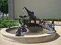
In the north-west stood Sarrasani's circus theater 5000 , which was destroyed in the war and which is reminiscent of the Sarrasani fountain designed by Vinzenz Wanitschke and a memorial plaque.
Sarrasani fountain

Sarrasani memorial plaque


The Blue House , a former university building of the Pedagogical Institute , formed the north-eastern end of Carolaplatz. After the demolition in 2011, the excavation pit that was created was converted into a parking lot in 2013 and thus given temporary use until the new construction.
traffic
From Carolaplatz, Köpckestrasse ( B 170 ) branches off to the west , Albertstrasse to the north and Wigardstrasse to the east .

From the tracks of the Dresden tram , which leads north-south on a separate track west of Albertstraße to the Carolabrücke, there is a junction in the form of a track triangle into Köpckestraße at Carolaplatz . The two stops of the same name "Carolaplatz (government district)" are located at the exit of Albertstraße ( DVB lines 3, 7, 8) and Köpckestraße (line 8).
Carolaplatz is part of a north-south axis that leads to it from Königsbrücker Straße ( B 97 ) via Albertplatz (junction with B 6 ) and Albertstraße . From Carolaplatz, this traffic axis runs as the B 170 over the Carolabrücke, Rathenauplatz, St. Petersburger Straße (with Pirnaischer Platz , Georgplatz , Wiener Platz , Am Hauptbahnhof ), Fritz-Löffler-Straße and Bergstraße (with Fritz-Foerster-Platz ) through the city towards federal motorway 17 . Starting at Albertplatz, it has at least two lanes in each direction and often a structural separation of the directional lanes.
In an east-west direction, the square is part of a street that runs on the elevated bank of the Elbe in an arc south around the Inner New Town and passes the four inner-city bridges in front of it. It starts at Rosa-Luxemburg-Platz ( Albertbrücke ) and passes the perennial garden and the Königsufer as Wigardstraße . At Carolaplatz, the two lanes of the street are structurally separated and merge into Köpckestrasse (B 170), which from Neustädter Markt ( Augustusbrücke ) leads as Große Meißner Strasse in the direction of Palaisplatz , where it already runs north-northwest. At the end of this, the street takes on the Kleine Marienbrücke , which runs from Marienbrücke out of town , and at the same intersection the B 170 (Hainstraße, further north Hansastraße ) branches off in the direction of Neustädter Bahnhof . The traffic train continues as Robert-Blum-Straße to Antonstraße / Marienbrücke. Only then will the structural separation of the line leading through the Leipzig suburb as Leipziger Strasse be lifted.
Footnotes
- ^ Adolf Hantzsch : Name book of the streets and squares of Dresden (= messages of the Society for the History of Dresden . No. 17, 18 ). Wilhelm Baensch, Dresden 1905, p. 75 ( digitized version ).
Web links
- Places of the city of Dresden: Carolaplatz
- Carolaplatz in the Stadtwiki Dresden
Coordinates: 51 ° 3 ′ 26.4 " N , 13 ° 44 ′ 46.8" E