
Castro de las Cogotas
The heavily fortified fortress of Castro de Las Cogotas (also just called Las Cogotas ), located on a hill about 1100 to 1150 m high, is an archaeological site in the area of the municipality of Cardeñosa near the city of Ávila in Spain .

history

During the excavation, Las Cogotas provided two stratigraphic phases: One was in the late Bronze Age (Cogotas I - approx. 1700 to 1100 BC) and the other at the beginning of the Iron Age (Cogotas II - approx. 1000 to 800 BC). ) There is an unexplained hiatus in the middle . The study of Las Cogotas and Castro de Ulaca allowed a better understanding of the way of life on the peninsula before the Roman invasion (193 BC).
Las Cogotas was excavated in the 1920s under the direction of Juan Cabré (1882-1947) and is the most important reference to the Vettones , a Celtic tribal group that during the Iron Age inhabited an area that is now the provinces of Ávila and Salamanca and one each Included part of the provinces of Toledo , Zamora , Cáceres and Alto Trás-os-Montes in Portugal.
Excavation site

The Castro de las Cogotas offers a - partially reconstructed - double wall made of natural stones, which is reinforced by bastions . The remains of a number of stones have been preserved outside. The interior consists of a row of houses on the inside of the wall; the outdoor area to the south was used for livestock farming. The place was a center of handicraft activities like blacksmithing and pottery . According to its area, it is estimated that the fortress could accommodate around 250 people. On the outside, about 250 m from the wall, was a necropolis in which more than 1,400 graves were found, which were divided into four zones.

Verraco from Las Cogotas (today in Ávila)

bronze age ceramics from Las Cogotas
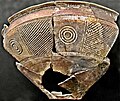
Ceramic from Las Cogotas


See also
literature
- Jesús R. Álvarez-Sanchís: Los Vettones (= Bibliotheca archaeologica Hispana. 1). 2a edición. Real Academia de la Historia, Madrid 2003, ISBN 84-95983-16-8 .
Web links
Coordinates: 40 ° 43 '40.3 " N , 4 ° 42' 5.3" W.