
Avila Province
|
Ávila Castile and Leon , Spain |
|
|---|---|
 coat of arms |
 flag |
| Basic data | |
| Autonomous Community : | Castile and Leon |
| Capital : | Ávila |
| Official language : | Spanish |
| Area : | 8,050 km² |
| Residents : | 157,640 (Jan 1, 2019) |
| Population density : | 19.58 inhabitants / km² |
| ISO 3166-2 : | ES-AV |
| Website : | diputacionavila.es |
| Location of the province of Avila | |
 .svg) |
|
Ávila is a western Spanish province in the southern part of the autonomous region of Castile and León . The capital of the province is Ávila of the same name . The province of Ávila has 157,640 inhabitants (2019) on 8,049.92 square kilometers.
location
Ávila borders the province of Toledo in the southeast, Cáceres in the southwest , Salamanca in the west, Valladolid in the north, Segovia in the northeast and the Autonomous Community of Madrid in the east .
Largest communities
| local community | Residents (January 1, 2019) |
|---|---|
| Ávila | 57,744 |
| Arévalo | 7,986 |
| Arenas de San Pedro | 6,377 |
| Las Navas del Marqués | 5.119 |
| Candeleda | 5,018 |
| Sotillo de la Adrada | 4,590 |
| El Tiemblo | 4,109 |
| Cebreros | 3,120 |
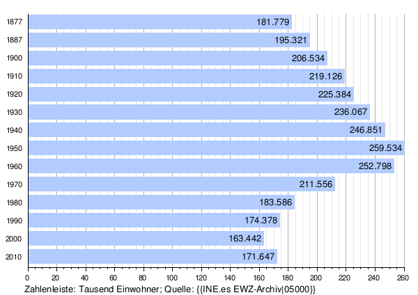
Population development of the province
landscape
Ávila can be divided into two zones: in the north the plateau in the valley of the Duero and in the south the Gredos Mountains , the highest mountain of which is the Pico Almanzor at 2592 meters.
climate
There is a continental Mediterranean climate with cool winters and hot summers. The annual average temperature is 11.5 ° C.
economy
Ávila is shaped by agriculture. Mainly wine, vegetables, potatoes and grain are grown. Livestock is farmed in the mountains. The industry is underdeveloped.
Others
The inhabitants are known as abulenses or avileses .
Web links
Individual evidence
- ↑ Cifras oficiales de población resultantes de la revisión del Padrón municipal a 1 de enero . Population statistics from the Instituto Nacional de Estadística (population update).
- ↑ Cifras oficiales de población resultantes de la revisión del Padrón municipal a 1 de enero . Population statistics from the Instituto Nacional de Estadística (population update).
Álava (Araba) | Albacete | Alicante (Alacant) | Almería | Asturias (Asturias) | Ávila | Badajoz | Balearic Islands (Illes Balears / Islas Baleares) | Barcelona | Biscay (Vizcaya) | Burgos | Cáceres | Cadiz | Castellón (Castelló) | Ciudad Real | Cordoba | A Coruña (La Coruña) | Cuenca | Gipuzkoa (Guipúzcoa) | Girona | Granada | Guadalajara | Huelva | Huesca | Jaén | Cantabria (Cantabria) | Lleida | León | Lugo | Madrid | Málaga | Murcia | Navarre (Nafarroa) | Ourense (Orense) | Palencia | Las Palmas | Pontevedra | La Rioja | Salamanca | Santa Cruz de Tenerife | Saragossa (Zaragoza) | Segovia | Seville | Soria | Tarragona | Teruel | Toledo | Valencia (València) | Valladolid | Zamora