Centa (Ligurian Sea)
| Centa | ||
| Data | ||
| location | Liguria , Italy | |
| River system | Centa | |
| River basin district | Appennino Settentrionale | |
| origin | Northwest of Albenga through the confluence of the Arroscia and Neva rivers 44 ° 3 ′ 16 ″ N , 8 ° 11 ′ 15 ″ E |
|
| Source height | 22 m slm | |
| muzzle | At Albenga in the Ligurian Sea Coordinates: 44 ° 2 '30 " N , 8 ° 13' 22" E 44 ° 2 '30 " N , 8 ° 13' 22" E |
|
| Mouth height | 0 m slm | |
| Height difference | 22 m | |
| Bottom slope | 7.3 ‰ | |
| length | 3 km | |
| Catchment area | 420 km² | |
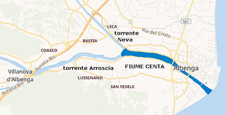
The Centa is a 3 km long river in Liguria . The Centa arises from the confluence of the Arroscia and Neva , flows in a southeastern direction through Albenga and then flows into the Ligurian Sea .
Individual evidence
Web links
Commons : Centa - collection of images, videos and audio files
