Centerville, Virginia
| Centerville | |
|---|---|
|
Location of Centerville in Fairfax County
|
|
| Basic data | |
| State : | United States |
| State : | Virginia |
| County : | Fairfax County |
| Coordinates : | 38 ° 51 ′ N , 77 ° 27 ′ W |
| Time zone : | Eastern ( UTC − 5 / −4 ) |
| Residents : | 71,135 (as of 2010) |
| Population density : | 2,302.1 inhabitants per km 2 |
| Area : | 31.2 km 2 (approx. 12 mi 2 ) of which 30.9 km 2 (approx. 12 mi 2 ) is land |
| Height : | 117 m |
| Postcodes : | 20120 - 20122 |
| FIPS : | 51-14440 |
| GNIS ID : | 1491083 |
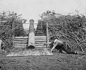
 Quaker Gun at Centerville in March 1862 |
|
Centerville is a place ( CDP ) in Fairfax County at the junction of Interstate 66 from US Highway 50 near Washington, DC in the US state of Virginia .
In the winter of 1861/1862 of the Civil War , the Confederate Army was in position here and received the initial equipment with the flag of the Confederate States of America ; In addition, the Bull Run is located on the western edge of the municipality , the scene and namesake of two battles .
Local baseball club SYA East LL has represented Virginia twice in regional youth competitions .
Personalities
- Caron Butler (born 1980), basketball player
- Ormond Stone (1847-1933), mathematician
Web links
Commons : Centerville, Virginia - Collection of images, videos, and audio files
