
Mulanje (mountain range)
| Mulanje | ||
|---|---|---|
 Satellite image |
||
| Highest peak | Sapitwa ( 3002 m ) | |
| location | Malawi , Southern Africa | |
|
||
| Coordinates | 15 ° 57 ′ S , 35 ° 36 ′ E | |
| Age of the rock | 130 million years | |

The Mulanje massif in Malawi is a mountain massif that rises 70 km south of Blantyre from the extensive tea plantations on the lowest slopes of its mountain range. The highest point of the Mulanje mountain range and at the same time the highest mountain in Central Africa is the Sapitwa at 3002 m . Its most spectacular peak is the Chambe ( 2556 m ), which rises 1500 m from the flat grass savannah between it and the Shire highlands . Its approximately 700 to 800 m high, almost vertical west face is the highest rock face in all of Africa.
The massif is a rain catcher because of its height. It can rain up to 1800 mm per year. It was formed 130 million years ago by magma outflow. The volcanic crater walls of the Phalombe and the Chambe can still be seen today and are spectacular with their shiny granite.
Economic use
On the Mulanje massif, as on the neighboring Phalombe ( 2289 m ), intensive silviculture is practiced with a Mexican pine species. For a few years, attempts have been made to cultivate the native Widdringtonia whytei more intensively, the resin of which has a fly-repellent, if not fly-killing effect, like the oil of the pyrethrum chrysanthemum in Kenya.
Hydropower plants are repeatedly being considered, as the Chapaluka and Ruo rivers carry water continuously all year round and offer a height difference of over 1000 m over a short distance.
tourism
For political reasons, Malawi did not develop a tourism industry. Western-style hotels are only available in larger cities, in the national parks and on Lake Malawi . Malawi is still considered a destination for exclusive safari tourism for small groups and Spartan backpackers . Because of its ruggedness, gigantic granite walls and impressive height, the Mulanje massif is a popular daily destination for safari tourists visiting Malawi. Tourists who want to hike up on the plateau need not only complete equipment, but also local guides. In Blantyre and Lilongwe, excellent maps on a scale of 1: 30,000 are available, which allow a very good orientation. The terrain is sometimes very difficult and the differences in altitude are large. A stable cycle is essential. There are a few forest management huts on the plateau, but there is no catering. But alpine hikers are offered everything from montane, pine and cloud forests to high alpine meadows, rock crevices and ridge paths. The terrain can be so rugged with huge rubble that one kilometer as the crow flies requires a good three hours. From Blantyre a road leads over Thyolo through endless tea plantations and Luchenza to the mountain range, which then leads on to the border with Mozambique .

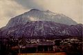
Mulanje massif with Chambe summit (left)
The Chambe peak of the Mulanje massif
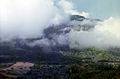
The Sapitwa peak of the Mulanje massif seen from the southwestern edge of the Lichenya plateau (almost never seen without clouds)

Widdringtonia whytei on the Mulanje plateau


Web links
- Sapitwa on Peakbagger.com (English)
- Mulanje Mountain Conservation Trust (nature conservation project). Archived from the original on February 11, 2013 ; Retrieved December 30, 2006 .
- Mulanje hiking. Mountain Club of Malawi , accessed November 18, 2014 .
- Mulanje Routes and Times. Mountain Club of Malawi , accessed November 18, 2014 .
- Panoramic photo from Mount Namasile. (JPG; 233 kB) Mountain Club of Malawi , archived from the original on March 4, 2016 ; accessed on December 4, 2019 (English, original website no longer available).