Chamoim
| Chamoim | ||||||
|---|---|---|---|---|---|---|
|
||||||
| Basic data | ||||||
| Region : | Norte | |||||
| Sub-region : | Cávado | |||||
| District : | Braga | |||||
| Concelho : | Terras de Bouro | |||||
| Freguesia : | União das Freguesias de Chamoim e Vilar | |||||
| Coordinates : | 41 ° 44 ′ N , 8 ° 16 ′ W | |||||
Chamoim is a former municipality ( freguesia ) in northern Portugal . It is located in the Peneda-Gerês National Park .
history
The current location may have been created during the medieval Reconquista . A first church is listed in the royal registers from 1220.
In 1758 Sequeirós was the capital of the administrative district, to which eleven parishes belonged, including Chamoim.
administration
Chamoim was a community ( freguesia ) in the district ( concelho ) of Terras de Bouro , in the district of Braga . The community had an area of 8 km² and 291 inhabitants (as of June 30, 2011).
The community was made up of seven localities:
- Chao de Pinheiro
- Frigueira
- Lagoa (main town)
- Padrós
- Pergoim
- Santa Comba
- Sequeirós
With the municipality reform on September 29, 2013 , the municipalities of Chamoim and Vilar were merged to form the new municipality of União das Freguesias de Chamoim e Vilar . Chamoim became the seat of this newly formed community.
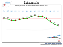
Population development
The community is characterized by migration and aging.
| Population in the municipality of Chamoim (1864–2011) | ||||||||||||||
|---|---|---|---|---|---|---|---|---|---|---|---|---|---|---|
| 1864 | 1878 | 1890 | 1900 | 1911 | 1920 | 1930 | 1940 | 1950 | 1960 | 1970 | 1981 | 1991 | 2001 | 2011 |
| 539 | 533 | 471 | 481 | 507 | 546 | 547 | 615 | 649 | 619 | 617 | 544 | 432 | 350 | 291 |
Culture, education and sights
The listed parish church Igreja de São Tiago dates back to the 18th century and dates back to a first sacred building from the 13th century.
There is a primary school in the former municipality of Chamoim.
The 9 km long hiking trail Trilho Pedestre dos Moinhos e Regadios Tradicionais , marked PR 4 (see list of hiking trails in Portugal # List of short hiking trails (PR) ), leads past rivers and water mills. Most of the old watermills on the Rio Homem are well preserved.
The sports and leisure club Associação Cultural Recreativa e Desportiva de Chamoim is an important player in Chamoim's community life .
economy
There are farms, construction, trade and catering in the area of the former municipality of Chamoim. The best known and most important company is Àguas do Fastio , based in Pergoim. Founded in 1979, the company is now a nationally known brand for mineral water.
Web links
- Map of the Freguesia Chamoim at the Instituto Geográfico do Exército
- Chamoim website at Terras De Bouro County Council
- Entry to Chamoim in the Mapas de Portugal
Individual evidence
- ↑ entry to the parish church of Chamoim in the Portuguese monument list SIPA (under Cronologia ), accessed on April 18, 2018
- ↑ a b page on Chamoim at the district administration of Terras de Bouro, accessed on April 18, 2018
- ↑ www.ine.pt - indicator resident population by place of residence and sex; Decennial in the database of the Instituto Nacional de Estatística
- ^ Publication of the administrative reorganization in the Diário da República gazette of January 28, 2013, accessed on October 1, 2014
- ↑ Entry on the parish church of Chamoim in the Portuguese list of monuments SIPA, accessed on April 18, 2018


