Cherokee, North Carolina
| Cherokee | ||
|---|---|---|
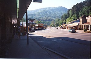
 Cherokee: Main Street |
||
| Location in North Carolina | ||
|
|
||
| Basic data | ||
| State : | United States | |
| State : | North Carolina | |
| County : | Swain County | |
| Coordinates : | 35 ° 29 ′ N , 83 ° 19 ′ W | |
| Time zone : | Eastern ( UTC − 5 / −4 ) | |
| Residents : | 2,138 (as of 2010 ) | |
| Height : | 605 m | |
| Postal code : | 28719 | |
| Area code : | +1 828 | |
| FIPS : | 37-12140 | |
| GNIS ID : | 1019613 | |
| Website : | www.cherokee-nc.com | |
Cherokee is a city in Swain County , North Carolina in the southeastern United States , where the Eastern Band of Cherokee Indians have their headquarters.
It is the capital of the Qualla Boundary Cherokee Indian Reservation , which covers an area of 230 km².
The area is well developed for tourism and is located in the Appalachian Mountains between the entrance to the Great Smoky Mountains National Park and the southern end of the Blue Ridge Parkway on the Oconaluftee River.
Since 1950, Cherokee Indians have performed the open-air play Unto These Hills several times a week during the summer season , which tells of the fate and displacement of the Cherokee .
Film set
The ending of the 1977 film Stroszek by Werner Herzog was shot in Cherokee, as was parts of the 1999 film On the Stormy Way with Sandra Bullock and Ben Affleck .
