Cheyenne Mountain
| Cheyenne Mountain | ||
|---|---|---|
|
Cheyenne Mountain |
||
| height | 2915 m | |
| location | Colorado Springs , Colorado , USA | |
| Mountains | Front Range , Rocky Mountains | |
| Dominance | 3 km → Sugarloaf Mountain | |
| Notch height | 338 m | |
| Coordinates | 38 ° 44 '39 " N , 104 ° 50' 48" W | |
|
|
||
|
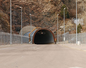
Entrance gate of the Cheyenne Mountain Operations Center |
||
|
Reinforced door of the Cheyenne Mountain Operations Center |
||
The Cheyenne Mountain , a mountain in the Rocky Mountains on the south side of Colorado Springs in the US state of Colorado has become known through the present in his US military base Cheyenne Mountain Operations Center (CMOC) .
Geography and history
The highest point of the three-peaked Cheyenne Mountain is the 2915 m high central peak, while the two secondary peaks reach a height of 2800 m. The mountain is bounded by the watercourse of Rock Creek , which flows to the southeastern town of Fountain , as well as Cheyenne Canyon to the north and the Pike National Forest to the west . The city of Colorado Springs is just over 6 miles to the northeast.
The military facility CMOC was formerly called Cheyenne Mountain Air Force Station (CMAFS) and included the North American Aerospace Defense Command (NORAD) and the space satellite surveillance Space Detection and Tracking System (SPADATS). Around 1,400 people worked under the mountain until the base was taken out of service in July 2006 and placed in "warm standby" status. The reason was the disappearance of the original nuclear threat and the availability of a nearby Air Force base , which could take over the functions of the CMOC. The bunkers themselves are located 700 m deep in the mountain, which is made of the hardest granite, with the current workforce of around 500. The plant is self-sufficient in terms of water supply, has its own power plant and could work for several weeks isolated from the outside world in the event of a war. In addition, the central bunker buildings are mounted on steel springs that can absorb vibrations from earthquakes or nuclear strikes.
The Will Rogers Shrine of the Sun is located on the eastern slope of the mountain at an altitude of about 2,400 m . It is a granite-clad tower that serves as a mausoleum and was built in honor of the entertainer Will Rogers .
media
The series Stargate - Kommando SG-1 and its offshoots contributed to the popularity of the mountain , as one of the main scenes is located in the mountain. The classic tunnel entrance to the NORAD complex can often be seen in the series' establishing shots .
The film WarGames , in which a teenage hacker accidentally brings the world to the brink of nuclear war, shows the complex as one of the main locations of the film, as the authors, u. a. based on visits during public tours in the 1980s.
The large, round entrance gate of the complex, which was let into the mountain, is also shown in many other series and films. These include films from the Terminator series and Independence Day .
The future and the slow decay of the facility after a fictional disappearance of mankind is shown in episode 9 of the 2nd season of the documentary fiction series Future Without People (“Danger from the Deep”, USA 2010).
Web links
- Friederike Freiburg: Cheyenne Mountain: The quiet end of the superbunker . SpiegelOnline from October 20, 2006.
- Cheyenne Mountain on Peakbagger.com (English)
Individual evidence
- ↑ a b TV documentary at Galileo on ProSieben (episode 257) from September 19, 2016, accessed on August 25, 2018


