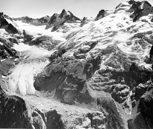
Chickamin Glacier (Washington)
| Chickamin Glacier
( Chickamin Glacier )
|
||
|---|---|---|
|
The Chickamin Glacier in 1965 |
||
| location | Chelan County , Washington , USA | |
| Mountains | Cascade chain | |
| Type | Kar glacier | |
| length | 2.6 km | |
| Altitude range | 2621 m - 1707 m | |
| Coordinates | 48 ° 18 ′ 39 ″ N , 121 ° 1 ′ 9 ″ W | |
|
|
||
| drainage | → Spruce Creek → South Fork Agnes Creek → Agnes Creek → Stehekin River | |
| particularities | ends in an ice fall / on bare rock; declining | |
The Chickamin Glacier is located in the Wenatchee National Forest in Washington state . It flows north of Dome Peak and Sinister Peak from 8,600 ft (2,621 m) down to about 5,600 ft (1,707 m). The Chickamin Glacier is separated from the Dome Glacier in the south and the Dana Glacier in the west by mountain ridges. The relatively narrow tongue of the 2 mi (3 km) wide glacier retreated 800 ft (244 m) between 1998 and 2006.
Individual evidence
- ↑ TopoQwest (United States Geological Survey Maps). Dome Peak, WA [map]. Retrieved March 10, 2013.
Web links
- Chic fireplace Glacier ( English ) In: Geographic Names Information System . United States Geological Survey . Retrieved March 10, 2013.

