Sino-Korean friendship bridge
Coordinates: 40 ° 6 ′ 54 ″ N , 124 ° 23 ′ 33 ″ E
| Sino-Korean friendship bridge | ||
|---|---|---|
| Sino-Korean friendship bridge | ||
| use | Road and rail | |
| Crossing of | Yalu | |
| place | Dandong / Sinŭiju | |
| construction | Steel bridge | |
| overall length | 940.8 meters | |
| start of building | April 1937 | |
| completion | May 1943 | |
| location | ||
|
|
||
| Chinese name | |
|---|---|
| Traditional : | 中朝 友誼 橋 |
| Simplified : | 中朝 友谊 桥 |
| Pinyin : | Zhōng cháo yǒuyì qiáo |
| Wade-Giles : | Chung Ch'ao yu-i ch'iao |
| Korean name | |
| korean alphabet : | 조중 우의 교 |
| Chinese characters : | 朝 中 友誼 橋 |
| Revised Romanization : | Jojunguuigyo |
| McCune-Reischauer : | Chojunguŭigyo |
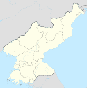
The Sino-Korean Friendship Bridge , also known as the Sino-Korean Friendship Bridge, is a bridge over the Yalu River ( Korean : Amnok) on the Sino-North Korean border . It connects the cities of Dandong in China and Sinŭiju in North Korea . The bridge is a symbol of the history of Sino-North Korean solidarity . Pedestrians are not allowed to cross the bridge. One of the few ways to enter or exit North Korea is by car or rail. In addition to tourists, mainly goods and raw materials from both countries are transported over the bridge.
The bridge was renamed from Yalubrücke to its current name in 1990 . It was built by the Imperial Army of Japan between April 1937 and May 1943, during the Japanese occupation of Korea and Northeast China. In 2010 the New Yalu Bridge was built downstream .
The Friendship Bridge represents North Korea's current drive for economic development and China's sustained strategic interest in the stability of its old ally.
Geographical location
The Chinese-North Korean border is 1,420 kilometers long and extends from west to east over the Yalu, the mountains around the Paektusan and the Tumen . The two rivers serve as a natural border. The Yalu is located in western North Korea and is a total of 813 kilometers long and rises at an altitude of 2500 meters on the Paektusan in the Changbai Mountains .
The bridge that connects the cities of Dandong and Sinuiju is located about 35 kilometers before the Yalu flows into the Yellow Sea.
history
Originally, the bridge was built by the Japanese during the occupation of Korea and parts of northeast China. The bridge connected the Korean peninsula with Manchukuo , two areas under colonial occupation, and should make it easier for Japan to make the conquest of Asia.
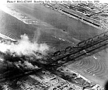
In front of this bridge there was an older steel bridge that was built between May 1909 and October 1911. It had a span of 944.2 meters and rested on twelve stone piles. Both Yalu bridges were destroyed by US bombers in November 1950 during the Korean War. Until February 1951, the United States used B-29 bombers and F-80 fighter bombers to repeatedly destroy the bridge, thereby stopping deliveries from China to the North Korean " brother people ". Because of this destruction, the Chinese volunteer army entered the Korean War .
The first bridge from 1911 remained destroyed and was named 断桥 ( Duàn qiáo , meaning broken bridge ). The destroyed bridge, which was built in 1943, has been repaired.
North Korea is not repairing the "broken bridge" so that the US cannot deny that it destroyed the bridge. Four of the ancient arches that gave the bridge the name "Broken Bridge" are on the Chinese side of the river.
The Friendship Bridge was expanded on the Chinese side with parks and promenades and serves as a tourist attraction. The area is known as the Yalu River Scenic Zone .
In 2010, China built the New Yalu Bridge downstream .
tourism
On the Chinese side, the bridges are surrounded by parks and boardwalks that make up the Yalu River Scenic Zone , a tourist attraction in China. On tourist boats it is possible to see the bridges from the river.
The four remaining arches of the old Yalu Bridge were opened as a tourist attraction in 1993 and equipped with lighting. Tourists can take a look at North Korea through the bridge itself, as well as through various river tours.
The damage caused by the US bombs can be seen through pedestrian streets. In 2006, the "broken bridge" received protection as an important cultural relic by the State Council of China .
Web links
literature
- King, FH, 2016, 4000 years of agriculture in China, Korea and Japan, ISBN 3-922201-05-9
further reading
- Stöver, Bernd, 2013, History of the Korean War, ISBN 978-3-406-64447-4
- Kim, Dong-Choon, 2007, The Korean War and Society, ISBN 978-3-89691-658-7
Individual evidence
- ^ A b c d e The Asia Pacific Journal: The Korean War and Sino-North Korean Friendship. In: The Asia-Pacific Journal: Japan Focus. Retrieved January 30, 2017 .
- ↑ Sören Urbansky: China's Commemoration of the Korean War: The Old Man and the Museum . In: Neue Zürcher Zeitung . September 8, 2015, ISSN 0376-6829 ( nzz.ch [accessed January 30, 2017]).
- ^ Border town in China: A look at North Korea - in the "empire of evil" - WORLD. Retrieved January 30, 2017 .
- ↑ Till Fähnders: China's border with North Korea: Even the “villas” look poor . In: Frankfurter Allgemeine Zeitung . June 22, 2010, ISSN 0174-4909 ( faz.net [accessed January 30, 2017]).


