Tumen (river)
|
Tumen Tumen Jiang, Tumennaja, Tumangang, Tumannaja, Tuman |
||
|
Tumen near Songhak-ri |
||
| Data | ||
| Water code | RU : 20040000412118200011492 | |
| location |
North Korea , Jilin ( PR China ), Primorye Region ( Russia ) |
|
| River system | Tumen | |
| Headwaters | on the eastern flank of the Paektusan in the Changbai Mountains 41 ° 58 ′ 10 ″ N , 128 ° 10 ′ 56 ″ E |
|
| Source height | approx. 2000 m | |
| muzzle | in the Sea of Japan Coordinates: 42 ° 25 ′ 47 " N , 130 ° 36 ′ 41" E 42 ° 25 ′ 47 " N , 130 ° 36 ′ 41" E |
|
| Mouth height | 0 m | |
| Height difference | approx. 2000 m | |
| Bottom slope | approx. 3.8 ‰ | |
| length | 521 km (according to other sources 549 km) | |
| Catchment area | 41,200 km² | |
| Big cities | Tumen | |
| Medium-sized cities | Namyang | |
| Small towns | Chassan , Tumangan | |
|
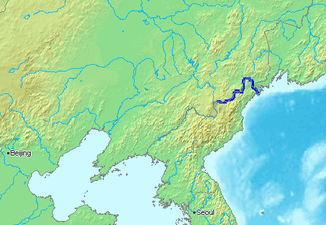
Location of the Tumen in East Asia |
||
|
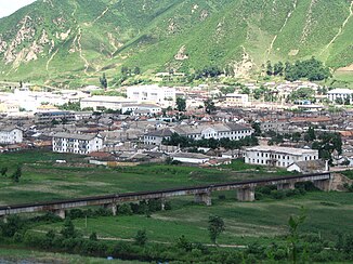
Bridge to Namyang |
||
|
View from Chinese Tumen over the river to Namyang (North Korea) |
||
| Tumen | |
|---|---|
| Chinese name | |
| Abbreviation | 图 们 江 |
| Long characters | 圖 們 江 |
| Pinyin | Túmen Jiāng |
| Korean name | |
| Chosŏn'gŭl | 두만강 |
| Hancha | 豆 滿江 |
| McCune-Reischauer | Tuman-gang |
| Revised Romanization | Duman-gang |
| Russian name | |
| Cyrillic | Туманная |
| transcription | Tumannaja |
The Tumen (also called Tuman ) is a river in Northeast Asia .
The Tumen rises on the eastern flank of the Paektusan volcano in the Changbai Mountains on North Korean territory. It flows mainly in an easterly and later in a north-easterly direction and forms the North Korean- Chinese border after just a few kilometers . In the lower reaches the river turns to the south and southeast and forms the border between North Korea and Russia for the last 17 km . Finally the Tumen flows into the Sea of Japan . The Tumen has a length of 521 km. Its main tributaries are Hongqi He红旗 河, Gaya He嗄 呀 河, Burhatong He布尔哈 通河, Hailan He海兰 河, and Hunchun He珲春 河.
The bridge over the Tumen, built in 1941, from the Chinese Tumen over the river to Namyang in North Korea is at ( ⊙ ). In October 2016, a new bridge, jointly built by both states, was inaugurated. The new bridge, about 20 kilometers away, is primarily used for road traffic. The name of the river comes from the Jurchen language and means "ten thousand".
The Tumen is also the most used transition from North Korean refugees to China, as it is not as deep and wide as the Yalu .
Web links
Individual evidence
- ↑ a b Article Тумыньцзян in the Great Soviet Encyclopedia (BSE) , 3rd edition 1969–1978 (Russian)
- ↑ Река Тумыньцзян (Тюмень-Ула, Туманган) in the State Water Register of the Russian Federation (Russian)
- ↑ Opening ceremony for New Tumen River Bridge held: SBS. In: nknews.org. Retrieved July 1, 2018 .
- ^ Norimitsu Onishi: Tension, Desperation: The China-North Korean Border. In: The New York Times . October 22, 2006, accessed November 27, 2016 .


