Chiradzulu
| Chiradzulu | ||
|---|---|---|
|
|
||
| Coordinates | 15 ° 43 ′ S , 35 ° 12 ′ E | |

|
||
| Basic data | ||
| Country | Malawi | |
| Southern region | ||
| District | Chiradzulu | |
| ISO 3166-2 | MW-CR | |
| height | 1000 m | |
| surface | - | |
| Metropolitan area | 767 km² | |
| Residents | 1600 (2006) | |
| Metropolitan area | 236.050 | |
| density | - | |
| Metropolitan area | 307.8 Ew. / km² | |
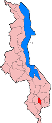
Chiradzulu is a small town at 1000 m altitude with 1600 inhabitants (2006 estimate) in Malawi north of Blantyre on the Shire highlands at the eastern foot of the mountain of the same name (1773 meters) and capital of the district of the same name with an area of 767 km² and a population from 236.050.
Chiradzulu is on the Blantyre - Zomba road to the east in the middle of fields. Nevertheless, the district shares the lowest ranks of food security in the country with Kasungu and Mulanje for various reasons, because as a pure highland district it is prone to droughts. The rain shadow of the Mulanje massif can reach here. In addition, many fields are fallow because AIDS sufferers lack the strength to cultivate them. 25% of the population are infected. On average, each family owns half a hectare of land, which is completely sufficient for their subsistence.
The mountain Chiradzulu is a forest area and is under protection, but wood is extracted there. The lowest economic growth rates in Malawi from 1997 to 1998 were in Chiradzulu with 1.4%.
Chiradzulu has a 1,000 meter long runway, a primary school and a hospital. There are regular bus connections to Blantyre and Zomba .
Personalities
- John Chilembwe , Baptist minister and Malawian national hero, was born in Chiradzulu district in 1871.
