Dur Sarrukin (Assyria)
Dur Šarrukin , also Dur Scharrukin ( Assyrian wall / land fortress of Sargon; today's Chorsabad ), was an Assyrian city 16 km northeast of Nineveh in today's Iraq .
history
In the ninth year of his reign, Sargon II took over the old city of Magganubka at the foot of the Gebel Muzri and met in 713/712 BC. BC Preparations for the construction of his new royal residence. 712 BC In the third month of Simanu ("brick month ") , the Assyrian king began the first excavation work, followed by the inauguration of the foundation with the laying of the Temennu in the fifth month of Abu ("which is favorable for foundations") .
706 BC After six years of construction, Sargon II was able to move into his new palace. When he died two years later, however, his successor Sennacherib did not move the capital back to the old capital Kalhu ( Nimrud ), but to Nineveh in his south-west palace . The city was ravaged by the forces of a Babylonian - Median coalition in 612 BC. Chr. Destroyed.
Archaeological site
Excavation history
Paul-Émile Botta believed to have discovered Nineveh when he was discovered in 1843, but this quickly turned out to be wrong. Victor Place and Félix Thomas carried out excavations from 1851 to 1855 . In 1852, during a disaster while transporting artifacts to Paris, many reliefs sank in the Shatt el-arab and have not been found to this day. In 1928 (until 1935) the excavations were resumed by the Oriental Institute in Chicago under the direction of the archaeologists Henri Frankfort and G. Loud. The finds from Major Sharrukin are now spread across half the world and can be found in the Louvre in Paris, the British Museum in London , the Hermitage in Saint Petersburg , Baghdad and Chicago.
Archaeological evidence

The residence was not a city in the traditional sense, more like a citadel , was laid out almost square (1760 m by 1635 m) and covers an area of around 3 km². Dur Sharrukin was surrounded by a mighty wall with 183 towers and seven gates. The length of the walls corresponds exactly four SAR (14400 yards ), three NER (1800 yards), a US (60 yards), three pipe (18 yards) and two Ellen or converted 16280 Ellen (8140 m), the numeric equivalent of the name Sargon.
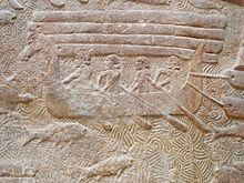
The huge royal palace was built on a 15 m high terrace, which dates back to 708 BC. Was completed. In the palace there were numerous representation and living rooms, temples and service wings. The residence was dominated by a presumably seven-step, 42.6 m high ziggurat . The palace was decorated with bas-reliefs depicting Sargon's campaigns and statues of porters. The gatekeepers were hybrids, either human-headed bulls or winged hybrids. The palace was the largest residence ever built in the Orient . In addition to the royal palace, the temple complexes (including a Nabu temple) and administrative buildings, there were also several prince's palaces within the citadel. Outside the walls there was another palace, as well as a second, even fortified palace, which was used as a residential building and arsenal .
The ruins of Tappa Gaura are located in the immediate vicinity of the city complex .
Destruction by the Islamic State
At the beginning of March 2015, it was announced that activists and fighters of the Islamic State (IS) had started to blow up parts of Dur Šarrukin and to loot the site. In the ideology of the IS, the Assyrian sculptures are considered idolatry , which is not compatible with Islam. Archaeologists and ancient scholars around the world reacted with indignation and horror.
literature
- Arno Kose: The spiral ramp of the Ziqqurrat of Dur-Šarrukin: no fantasy from the drawing table. In: Baghdader Mitteilungen 30. 1999, pp. 115–137 ( PDF; 5.1 MB ).
- Gordon Loud, Charles B. Altman: Khorsabad. 2 volumes. Chicago 1936-38.
- Eckhard Unger: Dûr-Sharrrukîn. In: Real Lexicon of Assyriology and Near Eastern Archeology . Volume 2. Berlin 1938, pp. 249-252.
Web links
- Dur Šarrukin at Livius.org (English)
- Dur Šarrukin on Google Arts & Culture
- Site of Khorsabad Relief Project (English)
Individual evidence
- ↑ Destroyed cultural heritage: Iraq asks for help. dw.de, March 8, 2015, accessed March 9, 2015 .
- ↑ Destruction in Iraq: IS militias blow up the ancient royal residence of the Assyrians on Spiegel.de on March 8, 2015. Accessed on March 8, 2015.
Coordinates: 36 ° 28 ′ 0 ″ N , 43 ° 12 ′ 0 ″ E

