Chrysomilia
|
Chrysomilia Χρυσομηλιά |
||
|---|---|---|
|
|
||
| Basic data | ||
| Country |
|
|
| region | North Aegean | |
| Regional district | Ikaria | |
| local community | Fourni Korseon | |
| Geographic coordinates | 37 ° 38 ′ N , 26 ° 31 ′ E | |
| Height above d. M. |
100 m Aegean Sea |
|
| Residents | 104 (2011) | |
| LAU-1 code no. | 5402000022 | |
| Telephone code | 22750 | |
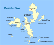
Chrysomilia ( Greek Χρυσομηλιά ( f. Sg. ) Also Chrysomilea (Χρυσομηλέα)) is a place in the north of the Greek island of Fourni . According to the 2011 census, the village had 104 inhabitants, the port of Kambi Chrysomileas (Καμπί Χρυσομηλέας) 50 inhabitants. Most of the villagers are fishermen or seafarers, and a few are farmers and ranchers. Due to years of poor accessibility, the village is affected by migration and aging.
| year | 1920 | 1928 | 1940 | 1951 | 1961 | 1971 | 1981 | 1991 | 2001 | 2011 |
| Residents | 133 | 151 | 166 | 147 | 180 | 165 | 157 | 130 | 133 | 154 |
Chrysomilia is about 100 m above the port. A little more than a kilometer northeast is the Korakas (Κόρακας), at 514 m the highest mountain on the island.
The 15 km long road to the main town of Fourni is currently (2008) being expanded for a planned 5.5 million euros. The EU contributes 75% of the costs.
Chrysomilia is connected to the ferry connection from Fourni via Thymena and Ikaria to Samos ( Karlovasi ).
Individual evidence
- ↑ Results of the 2011 census, Greek Statistical Office (ΕΛ.ΣΤΑΤ) ( Memento from June 27, 2015 in the Internet Archive ) (Excel document, 2.6 MB)
- ↑ Το χωριό της Χρυσομιλιάς ( Memento of the original from September 24, 2015 in the Internet Archive ) Info: The archive link was automatically inserted and not yet checked. Please check the original and archive link according to the instructions and then remove this notice. (Greek)
- ↑ Population of Chrysomilia with Kambi Chrysomileas 1920–2001, Greek Statistical Office ELSTAT, digital library (Greek)
- ^ Map 209, Ikaria / Fourni, 1: 50,000 . Road Editions, ISBN 960-8189-48-9 . ; Map NA 6, Samos - Ikaria, 1: 70,000 . Z-Editions, ISBN 960-6693-12-0 .

