Ciudad Darío
| Ciudad Darío | ||
|---|---|---|
|
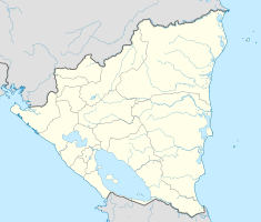
Coordinates: 12 ° 43 ′ N , 86 ° 7 ′ W Ciudad Darío on the map of Nicaragua
|
||
| Basic data | ||
| Country | Nicaragua | |
| Department | Metagalpa | |
| City foundation | 15th century | |
| Residents | 41,014 (2005) | |
| City insignia | ||
| Detailed data | ||
| surface | 735 km | |
| height | 432 m | |
| Time zone | UTC −6 | |
| Website | ||
Ciudad Darío , formerly San Pedro de Metapa or simply Metapa , is a municipality in the Matagalpa department in Nicaragua . It is located in the Metlalpán region. On February 25, 1920, the name of the municipality was changed in honor of the poet Rubén Darío , who was born there on January 18, 1867.
The etymological origin of the name 'Metapa' is in the Nahuatl language and roughly means 'stone savannah' or metate .
Rubén Darío described his place of birth in his autobiography as a small village or rather a clustered village in Nueva Segovia , which was already called Chocayos and Metapa.
Location and climate
This municipality is 45 km from the capital of the department, Matagalpa , and 90 km from the state capital Managua and is at an altitude of 432 meters.
The climate is tropical with frequent rainfall and temperatures between 25 and 28 ° C.
Boundaries and territorial composition
Ciudad Darío borders the following municipalities:
|
|
This municipality is made up of 22 comarcas rurales (districts) and the cabecera municipal , the core of the municipality.
- Rural comarcas
|
|
economy
As in most Central American countries, the economy is based on the primary economic sector. Trade has always been one of the most important activities, as people passing through have been looked after by residents here since the earliest times. After the construction of a bypass, however, the trade became less and less.
The primary economic sector is the most important of the municipality, although most of it is intended for personal consumption. In addition to beans , corn and sorghum , wheat and early vegetables are also grown. In addition, there is also cattle farming.
The secondary economic sector is hardly present in this zone. Only artifacts for tourists and bentonite for the soap factory are produced industrially.
The tertiary economic sector is based on tourism. Tourists who are attracted to Ruben Daríos' birthplace employ many residents and thus promote the growth of the municipality. There is also a hotel on the edge of the Carretera panamericana .
history
In the 16th century the first residents settled on the first country estates.
In 1627 Spanish missionaries of the Mercedarian order founded a reducción indígena in the valley of Metlalpán , which bore the name of the valley. The first name of the settlement was thus Chocoyos .
The monastery brother Agustín Morel de la Santa Cruz , who was bishop of Nicaragua and Costa Rica , had a map made during an apostolic visit in 1752, which at that time comprised 120 houses with thatched roofs and a single one with roof tiles. These apartments were loosened up by the plains. 2259 inhabitants, distributed among 340 families, were part of the former place. Even then, there were 59 haciendas (country estates) and 66 trapiches (mills) to make sugar from sugar cane. The place was formed by four streets and a square. All streets bore the name of an apostle (San Pedro, San Pablo, San Andrés y Santiago). At that time the municipality was renamed Metapa or San Pedro de Metapa.
Already in the 18th century many people from León settled there on their way to Granada . (That was also the reason why Rubén Darío was born in this municipality, even though his roots were in Léon.)
In 1891 Metapa gained city status.
After the death of Rubén Darius, the municipality was renamed on February 25, 1920 at the initiative of the citizens in honor of the King of Spanish Words . From then on, the municipality bears the name Ciudad Darío .
Attractions
The main attraction of the Municipios Ciudad Darío is the house where the poet was born, which is now a museum. The Museo Histórico Casa Natal Rubén Darío museum , which maintains the original structure, was declared a national attraction on February 6, 1943. It also has used furniture by Rubén Darío and an auditorium built in the garden.
The natural complex Laguna de Moyúa , Tecomapa and Las Playitas , is another attraction of the municipality. It is rich in biodiversity and has many recreational facilities.
Culture and festivals
Ciudad Darío's gastronomy is famous for its rosquillas darianas made from corn and for cosas de horno .
Among the dances held in the municipality and with guitars and violins accompanied the sting polka and mazurka out because they are European origin.
Festivals are organized in honor of the Virgin Fatima , John and la Purísima . On January 18th, the municipality celebrates the poet Rubén Darío.
Town twinning
- Sprockhövel ( Germany )
- Lutterbach ( France )
- Sabadell ( Spain )
- Reus ( Spain )


