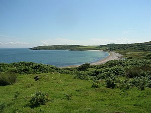
Claggain Bay
| Claggain Bay | ||
|---|---|---|
|
View over Claggain Bay |
||
| Waters | North channel | |
| Land mass | Islay | |
| Geographical location | 55 ° 42 '24 " N , 6 ° 2' 14" W | |
|
|
||
| width | approx. 1.2 km | |
| depth | 250 m | |
The Claggain Bay is a bay on the east coast of the Scottish Hebridean island of Islay . It is located about six kilometers south of McArthur's Head and 15 km southeast of the island's capital Bowmore . The approximately 1.2 km wide bay cuts 250 m deep into the country. In the south it is bounded by Cape Trudernish Point . The neighboring bay of Aros Bay is south of Trudernish Point . A small stream called the Claggain River , which rises on the southern flank of the Beinn Bheigeir, flows into the middle . Although Claggain Bay is in a sparsely populated part of the island, it is accessible by road. The single-lane road leads from Port Ellen via Lagavulin , Ardbeg and Trudernish to Ardtalla, a few hundred meters north .
In 1878 a standing stone was described on the banks of the bay. This is said to have been around 1.2 m high with a base area of 46 × 30 m. However, he could not be found during an excursion in 1959. 70 meters south of the road bridge over the Claggain River are the remains of a house that is classified as military. Nothing is known about the origin and purpose of the building. On the night of October 3, 1906, the 12-ton Unity ran aground in Claggain Bay on its voyage from Belfast to Islay.
Individual evidence
- ^ Entry in the Gazetteer for Scotland
- ↑ Entry on Claggain Bay in Canmore, the database of Historic Environment Scotland (English)
- ↑ Entry on Claggain Bay in Canmore, the database of Historic Environment Scotland (English)
- ↑ Entry on Unity in Canmore, the database of Historic Environment Scotland (English)

