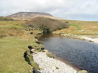
Claggain River
| Claggain River | ||
|
Estuary of the Claggain River |
||
| Data | ||
| location | Islay , Argyll and Bute , Scotland | |
| River system | Claggain River | |
| River basin district | Scotland RBD | |
| source | Outflow from Hole a 'Mhuilinn-ghaoithe 55 ° 44 ′ 4 ″ N , 6 ° 6 ′ 35 ″ W. |
|
| muzzle | about 1 km north of Trudernish in the Claggain Bay Coordinates: 55 ° 42 ′ 35 " N , 6 ° 2 ′ 24" W 55 ° 42 ′ 35 " N , 6 ° 2 ′ 24" W |
|
| Mouth height |
0 m ASL
|
|
| length | 8 kilometers | |
The Claggain River is a river on the Scottish Hebridean island of Islay . It arises as an outflow from Loch a 'Mhuilinn-ghaoithe on the slopes of Beinn Bheigier . It initially flows in a south-easterly direction following the Glen Leora valley and takes in numerous mountain streams. After about six kilometers, the course of the Claggain River then turns in an easterly direction. The river eventually flows two kilometers east into Claggain Bay .
The Claggain River runs through the hilly, sparsely populated areas in the southeast of the island. On its run it does not pass any settlement. Shortly before the mouth, the extension of the A846 , which connects Ardbeg with Ardtalla , crosses it . Just before the mouth of the river, there may be a Standing Stone on the banks of the Claggain River.
Individual evidence
- ↑ Entry on Claggain Bay in Canmore, the database of Historic Environment Scotland (English)
