Clifton, Arizona
| Clifton | |
|---|---|
 Old Town of Clifton |
|
| Location in County and Arizona | |
| Basic data | |
| State : | United States |
| State : | Arizona |
| County : | Greenlee County |
| Coordinates : | 33 ° 3 ′ N , 109 ° 18 ′ W |
| Time zone : | Mountain Standard Time ( UTC − 7 ) |
| Residents : | 2,265 (as of 2006) |
| Population density : | 58.8 inhabitants per km 2 |
| Area : | 38.8 km 2 (approx. 15 mi 2 ) of which 38.5 km 2 (approx. 15 mi 2 ) is land |
| Height : | 1060 m |
| Postal code : | 85533 |
| Area code : | +1 928 |
| FIPS : | 04-14380 |
| GNIS ID : | 0027713 |
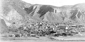
 Clifton in 1903 |
|
Clifton is a village in Greenlee County in the eastern US state of Arizona . Clifton has 2265 inhabitants (according to the 2006 census) on an area of 38.8 km². The population density is 67.5 / km². Clifton is also the county seat of Greenlee County.
history
Clifton was founded in 1865 by Mexican ore miners. In 1872, Jim and Bob Metcalf discovered copper near the village. In the same year they signed a peace treaty with the Apache Indians. The treaty allowed access to the area. Some suggest that the parish was named after Henry Clifton . Others suggest that Charlie Shannon named the parish Cliff Town because of the canyons and cliffs . The name was later shortened to Clifton.
traffic
Clifton is on US Highway 191 and north of the start of Arizona State Route 75 .
