
Col de Fouchy
| Col de Fouchy | |||
|---|---|---|---|
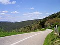
 Pass summit with a view from the north |
|||
| Compass direction | North | south | |
| Pass height | 606 m | ||
| Department | Bas-Rhin | Haut-Rhin | |
| Watershed | To water | Lièpvrette | |
| Valley locations | Fouchy | Lièpvre | |
| expansion | D155 | D48.1 | |
| Mountains | Vosges | ||
| profile | |||
| Ø pitch | 5.4% (302 m / 5.6 km) | 4.7% (335 m / 7.1 km) | |
| map | |||
|
|||
| Coordinates | 48 ° 18 '17 " N , 7 ° 15' 37" E | ||

The Col du Fouchy is a 606 m high pass in the Vosges on the border of the Bas-Rhin and Haut-Rhin departments .
The pass is located about 15 km west-northwest of Sélestat between the valley of Giessen and the valley of Lièpvrette to the north . The road connects the places Fouchy over the pass with Rombach-le-Franc and further with Lièpvre on the south side.
The approach from the north leads on the RD 155 alternately through meadows and shorter wooded areas and offers a clear view of the Giessen valley shortly before the pass. In the south, from the junction of the N 59, the RD 84.1 runs gently uphill along the Rombach through the two villages until it reaches the pass in the upper part of Rombach-le-Franc after a right-hand bend with a steeper gradient, mainly in the forest.
Exit north side

Exit south side

Travel bike with luggage on passport sign


Web links
Passport description at quaeldich.de