Corani lake
| Corani lake | ||
|---|---|---|

|
||
| Laguna Corani | ||
| Geographical location | Bolivia | |
| Tributaries | Río Jatun Mayu, Río Kenká Mayu | |
| Drain | Río Corani | |
| Places on the shore | Colomi | |
| Data | ||
| Coordinates | 17 ° 16 ′ 0 ″ S , 65 ° 54 ′ 0 ″ W | |
|
|
||
| Altitude above sea level | 3250 m | |
| surface | 18 km² | |
| length | 9.5 km | |
| width | 2.2 km | |
The Corani Lake (Spanish: Laguna Corani ) is an approximately 18 square kilometers large dam in the South American Andes -State Bolivia .
location
Lake Corani is located in one of the high valleys of the Bolivian Cordillera Oriental , halfway between the Altiplano and Chapare lowlands. It has a size of about 18 km² and extends over a length of 9.5 km and a maximum width of 2.2 km. The lake belongs to the municipality of Colomi and is located in the province of Chapare in the department of Cochabamba .
Transport network
The national road Ruta 4 runs along the east bank, with a length of 1657 km it crosses the entire country in a west-east direction. The road begins in the west at Tambo Quemado on the Chilean border, passes Cochabamba and Sacaba and after 430 km reaches the city of Colomi on the southern edge of Lake Corani. The road then continues in an easterly direction via Santa Cruz to Puerto Suárez in the Brazilian border area.
climate
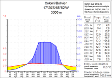
The climate of the region is temperate and a typical daytime climate , in which the temperature fluctuations between day and night are greater than between the cold and warm season.
The mean average temperature of the region is just under 11 ° C (see Colomi climate diagram), the monthly values fluctuate only slightly between 8 ° C in June / July and just under 14 ° C in November. The annual precipitation is around 550 mm, with a pronounced dry season from May to September with monthly precipitation below 15 mm, and a short humidity period from December to February with 90 to 120 mm monthly precipitation.
meaning
The lake supplies the urban region of Cochabamba, 50 km away, with drinking water and electricity, and the lake is also a popular destination for anglers and hikers.
Web links
- Corani: de represa a basurero de droga ( Spanish )

