
Coyote Buttes
| Coyote Buttes | |
|---|---|
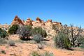
 Coyote Buttes South |
|
| location | Arizona / Utah , USA |
| part of | Colorado Plateau |
| Coordinates | 36 ° 58 '55 " N , 112 ° 0' 50" W |
| rock | Navajo sandstone |
| Age of the rock | Triassic and Jurassic |
The Coyote Buttes are a mountain range located mainly in the Vermilion Cliffs National Monument , they extend over the US state of Arizona and - in the northernmost part - Utah .
Location and limitation
The Coyote Buttes form the western edge of the Paria Plateau , which is also called Sand Hills in some sources. It is bounded to the east and south by the Poverty Flats, to the north and west by the Coyote Wash, which forms the House Rock Valley and the Wire Pass. The greatest height of the Coyote Buttes is reached at 1932 m . You are in the Vermilion Cliffs National Monument in Coconino County ( Arizona ), only the extreme north extends into the Grand Staircase-Escalante National Monument and thus Kane County in Utah .
As part of the Paria Canyon-Vermilion Cliffs Wilderness , geomorphologically they do not represent a uniform mountain range, rather a large number of small elevations are summarized under the name Coyote Buttes.
geology
The Coyote Buttes are part of the Colorado Plateau , some of the rocks typical of this region can also be found here. Only on the western edge of the area, where the erosion was accelerated by the temporarily water-bearing Coyote Wash, do rocks from the Chinle , Moenave and Kayenta Formations emerge , otherwise layers of differently colored Navajo sandstone , several hundred meters thick, determine the appearance . These are mostly petrified dunes of the Triassic or Jura, and steep hills known as teepees are characteristic.
In the area of Coyote Buttes, there are no permanent sources and no permanent watercourses after heavy - usually held in mid-summer - rainfall is temporary watercourses, which thus mostly the Coyote Wash and the form Buckskin Gulch the Paria River accrue. These mostly dry rivers separate the individual mountain ranges from one another, and there are also larger sandy or rocky plateaus.

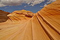
The Wave
Cottonwood teepees

Paw Hole Teepees
Second wave


Administration and access
The Coyote Buttes are administered by the Kanab Field Office of the Bureau of Land Management , the closest ranger station is located off Highway 89 near the bridge over the Paria River.
The area is under strict nature protection due to its unique and sometimes quite fragile sandstone formations. In order to penetrate the core areas of the Wilderness , you need a four-wheel drive vehicle in the southern part and at the Coyote Buttes North the visitor is faced with a hike through open terrain lasting several hours. There are no markings and are destroyed by rangers. An access permit (permit) is also required for both areas. Access to the north and south zones is only granted to a maximum of 20 people per day. Half of the permits for the Coyote Buttes North are issued four months in advance via the internet lottery and the rest on the day before the hike at the Grand Staircase-Escalante Visitor Center in Kanab. It is usually much easier to get the permits for the Coyote Buttes South (in the visitor center the day before or three months in advance on the Internet via calendar reservation).
The two trailheads for the hikes in the Coyote Buttes North Area are on the unpaved House Rock Valley Road , which runs west of the Coyote Buttes in the Coyote Wash Valley and connects Highway 89 with Highway 89A . In good weather they can usually even be reached by car. The vast majority of people start from the Wire Pass Trailhead, as the hike from the Notch Trailhead is significantly more impassable and challenging. The main attraction of the northern part is the large, undulating rock formation The Wave and is located about four kilometers from the parking lot at Wire Pass.
The Coyote Buttes South are only accessible via miles of deep sandy slopes. The main driveways branch east off House Rock Valley Road near Lone Tree Reservoir and Bowman's Corral. These slopes are only accessible with all-wheel drive vehicles and lead almost to the southern core zones (Paw Hole or the even more impressive Cottonwood Teepees).
Web links
- Details Permit award (English)
- Details and tips on issuing permits (German)