Creston, British Columbia
| Creston | ||
|---|---|---|
 |
||
| Location in British Columbia | ||
|
|
||
| State : |
|
|
| Province : | British Columbia | |
| Regional District : | Central Kootenay | |
| Coordinates : | 49 ° 6 ′ N , 116 ° 31 ′ W | |
| Height : | 597 m | |
| Area : | 8.47 km² | |
| Residents : | 5351 (as of 2016) | |
| Population density : | 631.8 inhabitants / km² | |
| Time zone : | Mountain Time ( UTC − 7 ) | |
| Postal code : | V0B 1G0 | |
| Foundation : | 1924 ( incorporated ) | |
| Mayor : | Ron Toyota | |
| Climate diagram | ||||||||||||||||||||||||||||||||||||||||||||||||
|---|---|---|---|---|---|---|---|---|---|---|---|---|---|---|---|---|---|---|---|---|---|---|---|---|---|---|---|---|---|---|---|---|---|---|---|---|---|---|---|---|---|---|---|---|---|---|---|---|
| ||||||||||||||||||||||||||||||||||||||||||||||||
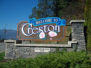
Creston is a small town in southeastern British Columbia , Canada . The small town with 5,000 inhabitants is located in the Regional District of Central Kootenay , about halfway between Castlegar and Cranbrook . It is located about 10 kilometers north of the border with the United States of America .
Creston is in the transition area from the Purcell Mountains to the Selkirk Mountains .
Creston is one of two settlements in southern British Columbia that do not have daylight saving time. The other settlement is Yahk . Furthermore, in contrast to the rest of the Regional District of Central Kootenay, Creston does not use Pacific Standard Time , but Mountain Standard Time .
history
In the Kutenai language , Creston is called kxunama? Nam . This means something like road to sea . The Kutenai settled in this area long before the first European settlement.
European exploration of the Creston Valley began around 1808 when David Thompson was exploring the region. He was followed first by the fur traders and prospectors and later by the surveyors for the railroad. With the construction of lines through the Canadian Pacific Railway and Great Northern Railway , the increased settlement of farmers began in the early 1880s.
Agriculture and forestry were the main industries in the new community. While mining attracted many people, the Creston Valley's mineral resources were not rich enough to support a profitable mining industry.
The settlement grew steadily in the following years and on March 1, 1899 a post office opened in Creston.
Demographics
The last official census , the 2016 Census , showed a population of 5,351 inhabitants for the settlement, after the 2011 census showed a population of 5,306 inhabitants for the municipality. Compared to the last census in 2011, the population increased by only 0.8% and developed significantly less than the provincial average, with a population increase of 5.6%. In the census period 2006 to 2011, the number of inhabitants in the municipality had decreased by 9.9%, while the provincial average only increased by 7.0%.
At the 2016 census, the average age of the residents was 52.2 years, well above the provincial average of 42.3 years. The median age of the residents was determined to be 57.7 years. The median age of all residents in the province in 2016 was 43.0 years. For the 2011 census, a median age of 55.2 years was determined for the residents of the municipality and 41.9 years for the residents of the province.
politics
The granting of local self-government for the municipality took place on May 14, 1924 ( incorporated as Village Municipality ). The status of a small town ( Town ) was given to Creston on July 26, 1966.
Mayor of the parish is Ron Toyota. Together with six other citizens, it forms the council of the small town (council).
economy
The economy in the Creston Valley is heavily influenced by agriculture and forestry. Due to its location, fruit and vegetable growing are particularly strong. However, grain cultivation has also increased again in recent years.
Another important employer is Columbia Brewery (now owned by the Anheuser-Busch-InBev Group), which has been brewing its Kokanee brand beer in Creston since 1959 .
In the last few years tourism has also become increasingly important as a source of income.
The median income of workers in Creston in 2006 was C $ 20,019, while at the same time the average for the entire province of British Columbia was C $ 24,867.
traffic
The Crowsnest Highway ( Highway 3 ) runs through the city in an east-west direction . Furthermore, Highway 3A and Highway 21 , which run in north-south direction, begin in Creston. Highway 3A connects Creston with Keremeos in the north of the province and Highway 21 connects the small town on the US-American border in the south.
About 7 kilometers southeast of the small town is the local airfield ( IATA airport code : -, ICAO code : -, Transport Canada Identifier: CAJ3). The airfield only has an asphalt runway that is 1,202 meters long.
Web links
Individual evidence
- ^ A b Creston Community Profile. Census 2016. In: Statistics Canada . August 9, 2019, accessed September 4, 2019 .
- ↑ Ktunaxa words. In: FirstVoices. Retrieved October 9, 2012 .
- ^ Creston Community Profile. Census 2011. In: Statistics Canada . May 31, 2016, accessed September 4, 2019 .
- ^ Origin Notes and History. Creston. In: GeoBC . Retrieved September 25, 2012 .
- ^ Council. In: Creston Valley. Retrieved September 20, 2015 .
- ^ Creston Community Facts. In: BCStats . Retrieved September 25, 2012 .
- ↑ Canadian Airports Charts. (PDF; 76.9 MB) NAV CANADA , accessed on September 4, 2019 (English).
