Crueize
| Crueize | ||
|
Viaduc de l'Enfer |
||
| Data | ||
| Water code | FR : O7120500 | |
| location | France , Occitania region | |
| River system | Garonne | |
| Drain over | Colagne → Lot → Garonne → Atlantic Ocean | |
| Confluence of two source streams | in the municipal area of Le Buisson 44 ° 36 ′ 5 ″ N , 3 ° 29 ′ 10 ″ E |
|
| Source height | approx. 1171 m | |
| muzzle | in the municipality of Saint-Léger-de-Peyre in the Colagne Coordinates: 44 ° 35 ′ 37 ″ N , 3 ° 17 ′ 55 ″ E, 44 ° 35 ′ 37 ″ N , 3 ° 17 ′ 55 ″ E |
|
| Mouth height | approx. 710 m | |
| Height difference | approx. 461 m | |
| Bottom slope | approx. 24 ‰ | |
| length | 19 km | |
| Reservoirs flowed through | Lac du Moulinet | |
The Crueize is a river in France that runs in the Lozère department in the Occitanie region . It is created by the confluence of the two source streams Ruisseau de Sinières and Ruisseau des Caves in the municipality of Le Buisson , initially drained through the Aubrac Regional Nature Park to the north, then turns to the southeast and flows around 19 kilometers into the municipality of Saint-Léger-de- Peyre as a right tributary to the Colagne .
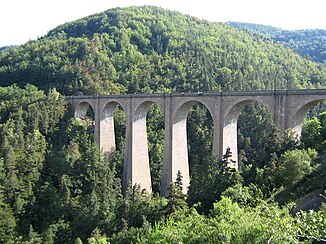
Near Le Buisson, the Crueize crosses under the A75 motorway and then continues in the deeply cut valley of Vallée de l'Enfer , where the Béziers – Neussargues railway spans the river with an imposing viaduct.
Places on the river
(Order in flow direction)
- La Recouse , municipality of Le Buisson
- La Vedrinelle , municipality of Peyre-en-Aubrac
- La Moulinet , municipality of Le Buisson
- Crueize , municipality of Peyre-en-Aubrac
- Saint-Léger-de-Peyre
Web links
Commons : Crueize - collection of images, videos and audio files
