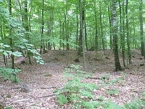
Custine ski jumps (Oberursel)
| Custine ski jumps | ||
|---|---|---|
|
The western one of the entrenchments |
||
| Creation time : | 1792 | |
| Castle type : | Height mounting | |
| Conservation status: | Burgstall | |
| Construction: | Earth wall | |
| Place: | Oberursel | |
| Geographical location | 50 ° 12 '35.9 " N , 8 ° 32' 37.3" E | |
|
|
||
The Custine ski jumps are a group of three gun positions in the Oberursel city forest on the Borkenberg , facing northeast on the valley path about 500 meters away. They are each 30 meters by 30 meters. The westernmost of the three entrenchments was lost due to the creation of the new local cemetery. They were each about 300 meters apart.
During the First Coalition War in November 1792, when the French revolutionary troops had occupied the Taunus, their commander, Count Adam-Philippe de Custine , ordered the entrenchments to be built in order to be able to defend himself better against the advancing Prussians and Hesse . The 4,000 men of the French army set up positions possessed a clear shot across the Urselbach the valley. However, the attack took place on December 2, 1792 by Hessian troops coming downhill from Oberreifenberg . On December 3, 1792, the French had to vacate the positions and withdrew to Frankfurt am Main via Kronberg and Eschborn .
In 1911 a working group of the Saalburg Museum carried out excavations. Except for cookware, however, there were no finds from the French troops.
gallery
Monument protection
The area of the ski jumps is a ground monument according to the Hessian Monument Protection Act . Investigations and targeted collection of finds are subject to approval, and accidental finds are reported to the monument authorities.
literature
- Karl August von Cohausen : The ramparts, military forces and old entrenchments of the administrative district of Wiesbaden. In: Annals of the Society for Nassau antiquity and historical research. Vol. 15, 1879, ZDB -ID 504639-7 , pp. 343-377, no. 94.
- Hermin Herr: Lexicon from the High Taunus. Mountains, paths, forests, history. Kramer, Frankfurt am Main 1993, ISBN 3-7829-0437-0 , p. 20.
- Günther Spahn: Similar to confusion ... In: Yearbook Hochtaunuskreis. 2000, ISSN 0943-2108 , pp. 183-185.


