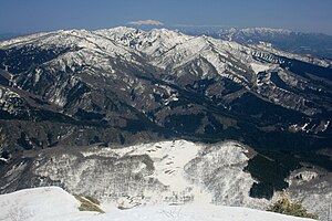
Dainichigatake
| Dainichigatake | ||
|---|---|---|
| height | 1709 m | |
| location | Honshū , Japan | |
| Mountains | Ryōhaku Mountains | |
| Coordinates | 36 ° 0 '5 " N , 136 ° 50' 16" E | |
|
|
||
| Type | Spring tip | |
| First ascent | 717 from Taicho | |
The Dainichigatake ( Japanese 大 日 ヶ 岳 ) is a 1708.9 m high mountain of the Ryōhaku Mountains on the Japanese main island of Honshū .
Overview
location
Originally the Dainichigatake marked the border between the provinces of Mino , Hida and Echizen . When the prefectures were introduced in 1871, parts of the mountain belonged to the Fukui and Gifu prefectures .
A member of the Fukui Prefecture village Itoshiro ( 石徹白村 , - mura ) was in 1958 at the prefecture-wide "Great community merger of Showa period " ( 昭和の大合併 , Showa no dai-gappei ) in the urban community Shiratori ( 白鳥町 , - chō ) (now part of the city of Gujō ) of the district of Gujō ( 郡 上郡 , - gun ) incorporated. From then on, the entire area occupied by the mountain belonged to the Gifu Prefecture.
Drain
The rainwater of the Dainichigatake flows through the rivers Nagara , Shō and Kuzuryū in three different directions.
First ascent
The mountain is said to have been climbed for the first time in 717 by the Buddhist monk Taichō , who is said to have worshiped the Buddha Mahāvairocana ( 大 日 如 来 , Dainichi nyorai ) on the summit .
use
There are three mountain hiking routes to the summit, from which the 2,702 m high Haku-san volcano can be seen.
The slopes of the mountain are used for winter sports.

