Dalijia Shan
| Dalijia Shan | ||
|---|---|---|
|
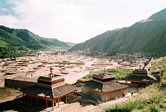
Dalijia Shan mountain ranges near Labrang |
||
| Highest peak | Dalijia Peak ( 4636 m ) | |
| location |
Gansu / Qinghai People's Republic of China |
|
|
|
||
| Coordinates | 35 ° 31 ' N , 102 ° 42' E | |
The Dalijia Mountains ( Chinese 达力加山 , Pinyin Dálìjiā Shān u. A.) Of is located on the northeastern edge of Qinghai-Tibet Plateau mainly in the area of greater community Ganjia in circles Xiahe of Autonomous Prefecture of Gannan Tibetan southeast of the northwest Chinese province of Gansu . Together with the 4080 m high Baleng Mountains (Baleng Shan 巴 楞 山) in Qingshui 清水 and the Taizi Mountains (Tàizǐ Shān 太子 山), the mountain range forms the mountain border between Xiahe County of Gansu and Xunhua County of Qinghai Province. The main summit with 4636 m meters is located on the famous Baishiya plain in the area of the large community of Labuleng (after the monastery of the same name ). The mountains above the snow line are steep, the cliffs are bare, snow falls all year round, the climate is unstable. The vegetation below the snow line thrives well, there are many flowers, the mountains are covered with a variety of high-quality grasses and valuable herbs and the mineral resources are rich. There are some shallow lakes in the mountains.
The Baishiya Cave is located on the south side of the mountains on the edge of the Ganjia Basin .
See also
Web links
Individual evidence
- ↑ Wang, Jie, et al. "Cosmogenic nuclide constraints on late Quaternary glacial chronology on the Dalijia Shan, northeastern Tibetan Plateau." Quaternary Research 79.3 (2013): 439-451. doi : 10.1016 / j.yqres.2013.01.004 ( PDF )
- ↑ Dalijia Shan - bytravel.cn (accessed on May 2, 2019)


