Dedza
| Dedza | ||
|---|---|---|
|
|
||
| Coordinates | 14 ° 20 ′ S , 34 ° 20 ′ E | |

|
||
| Basic data | ||
| Country | Malawi | |
| Central region | ||
| District | Dedza | |
| ISO 3166-2 | MW-DE | |
| height | 1600 m | |
| surface | - | |
| Metropolitan area | 3624 km² | |
| Residents | 30,928 (2018) | |
| Metropolitan area | 486,682 | |
| density | - | |
| Metropolitan area | 134.3 Ew. / km² | |
|
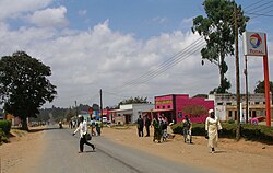
Main street of Dedza
|
||
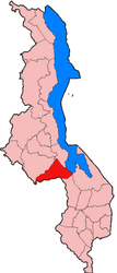
Dedza is a town in Malawi with 30,928 inhabitants (2018 census) on a 1600 meter high plateau between the Dedza Mountains on the paved main road M1 Blantyre - Lilongwe . It is the capital of the district of the same name with 3624 km² and 486,682 inhabitants (as of 2003).
The city has an airfield and is connected to the national bus network as well as to the electricity and telephone network. Dedza is a regional economic center with shops, handicraft businesses and lower administration.
Since the climate is comparatively harsh here, maize grows poorly in this region. However, the introduction of potato cultivation was successful and provided this region with a nutritional basis as far as Mozambique . The immediate location on the border with Mozambique plays an important role economically. Like Nsanje , Dedza is an economic, social and health center as far as Mozambique.
Pottery and ceramics are mainly produced in Dedza for the domestic market.
Nearby is the Iron Age Chencherere Cave , which is assigned to the Nkope culture and the early Munhumutapa Empire . Ten kilometers north of Dedze you can find numerous rock carvings of the Chewa and Batwa in the Chongoni Mountains . They were added to the UNESCO World Heritage List in 2006.
Dedza is the seat of the Diocese of Dedza .
Sons and daughters
- Emmanuele Kanyama (1962–2018), Roman Catholic clergyman, Bishop of Dedza
Web links
Individual evidence
- ↑ City Population: Population figures of the cities in Malawi 1977 to 2018 (English), accessed on September 22, 2019

