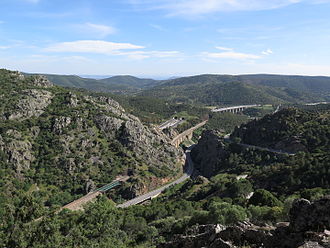
Desfiladero de Despeñaperros
| Desfiladero de Despeñaperros | |||
|---|---|---|---|
|
Despeñaperros |
|||
| Compass direction | south | north | |
| province | Jaén | Ciudad Real | |
| Valley locations | La Carolina | Almuradiel | |
| expansion | Pass road | ||
| Mountains | Sierra Morena | ||
| Map (Jaén) | |||
|
|
|||
| Coordinates | 38 ° 23 '10 " N , 3 ° 30' 25" W | ||
Despeñaperros ( German defile of Despeñaperros ) is in the north of the province of Jaen in the Sierra Morena situated mountain pass , which is protected as a nature park. The Despeñaperros pass, the only breakthrough through the Sierra Morena, has always been considered the gateway to Andalusia . The river of the same name winds through the picturesque mountain landscape in deep gorges. Deer and wild boar live in the forests, which are mainly made up of holm oak and cork oak , and occasionally lynx and wolves are seen. Today the N-IV national road from Córdoba to La Mancha runs through this pass.
The Desfiladero de Despeñaperros is vital to the history of Spain and the Reconquista . On July 16, 1212, an alliance of Christian kings led by Alfonso VIII of Castile won the battle of Las Navas de Tolosa over the Almohads and paved the way for Castile to conquer the south of the Iberian Peninsula .
The man who showed the King of Navarre this strategically important mountain pass was Martin Alhaja, an ancestor of the conquistador, explorer and travel writer Álvar Núñez Cabeza de Vaca ( Cabeza de Vaca , German cow head ), because the pass was marked with a cow head at that time.
Despeñaperros ravine, view of La Mancha .


