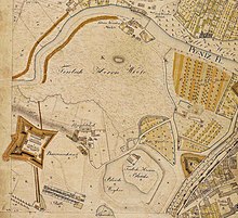
Deutschherrnwiese
The Deutschherrnwiese was an open space in the city of Nuremberg .
location
The area was about 500 meters west of the city wall on the southern bank of the Pegnitz . To the east of the Deutschherrnwiese was the Kontumazgarten , to the south of it the Himpfelshof . The small willow mill was on the north side of the meadow .
history
Originally the site belonged to the Teutonic Order , which had been based in Nuremberg with a commander since 1209 and owned a number of properties outside the then urban area west of the city wall . In addition to the Deutschherrnwiese, the Himpfelshof and the Kleinweidenmühle (until 1431) were owned by the order.
During the secularization as a result of the Reichsdeputationshauptschluss in 1806, the Deutschordenskommende Nürnberg was dissolved and the Deutschherrnwiese fell to the Kingdom of Bavaria . A parade ground was set up on the site in 1829.
At the turn of the 19th and 20th centuries, the area was used as a sports field. In May 1900, some high school students who played rugby games there founded 1. FC Nürnberg in a nearby restaurant . The club played its first home games on Deutschherrnwiese before moving to the sports field on Ziegelgasse in 1905 .
From 1919 to 1924 as well as in 1940 and 1941 the Nuremberg fair took place on the Deutschherrnwiese. With the exception of a sports facility belonging to the city of Nuremberg, the former meadow area is now built on. The Deutschherrnstrasse, which runs in this area and where the Nuremberg Finance Court has its seat, is reminiscent of the former name of the area .
Individual evidence
- ↑ Castles and mansions in the Nuremberg countryside - Himpfelshof (accessed on February 8, 2010)
- ↑ Our club - tradition since 1900! . In: www.fcn.de . 1. Football Club Nuremberg eV. Retrieved September 4, 2017.
- ^ Matthias Hunger: Franconian football home. Arete Verlag, Hildesheim 2017, ISBN 978-3-942468-91-6 , here pp. 130-131.
- ↑ Sports fields in Nuremberg (accessed on February 8, 2010)
literature
Michael Diefenbacher , Rudolf Endres (Hrsg.): Stadtlexikon Nürnberg . 2nd, improved edition. W. Tümmels Verlag, Nuremberg 2000, ISBN 3-921590-69-8 , p. 210 f., 447, 546 ( complete edition online ).
Coordinates: 49 ° 27 '18.5 " N , 11 ° 3' 43.3" E
