Kontumaz garden
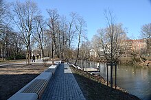
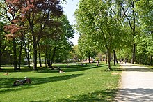
The Kontumazgarten is about 1.7 hectare park with children's playground in the Nuremberg district Kleinweidenmühle . The simple park is in front of the Hallertor in the west of the old town, on the left bank of the Pegnitz between the Großweidenmühlsteg and the Hallertorbrücke . Opposite on the other bank of the river is the Hallerwiese . Kontumazgarten is also the name of District 054 in District 05 Himpfelshof , the area of which is not identical to the green corridor.
history
In the late Middle Ages, the Kontumazanstalt stood on the road east of the Kleinweidenmühle to the Spittlertor, a quarantine station used in times of epidemics for arriving travelers and goods. Next to it was a large garden property, which was demolished in 1552 during the Second Margrave War in order to prevent the enemy from finding cover in the run-up to the city fortifications.
Georg Vargeth, a wealthy entrepreneur, built a mansion and a pond in 1669.
At the end of the 18th century there were 10 households in Kontumazgarten. The high court exercised the imperial city of Nuremberg with the Brandenburg-Ansbach Oberamt Cadolzburg and the Oberamt Schwabach . The landlords were the War Office of the Imperial City of Nuremberg (a house on the Schänzlein) and the Nuremberg owners von Forster (two gardens with eight houses) and von Volckamer (one garden with one house). With the community edict, Kontumazgarten was assigned to the Sündersbühl tax district formed in 1808 . It also belonged to the rural community Sündersbühl , which was founded in the same year . In 1825 Kontumazgarten was incorporated into Nuremberg . After the incorporation, the property began to decline. Thereafter, the site was divided into individual parcels, many of which were built on. In 1930 nothing was left of the buildings and gardens. Therefore, the park was rebuilt in the 1960s in the course of the flood exposure of the Pegnitz.
Todays situation
The district parking facility was redesigned in 2017 as part of the renovation of the Hallertorbrücke with urban development funds. A public participation accompanied the planning. A new pedestrian and bicycle path underpass below the Hallertorbrücke connects the quiet green area with the old town of Lorenz. The eastern and western entrance areas were redesigned and seating was created in the form of seating steps and a continuous bench directly on the water. A viewing platform at the eastern entrance area protrudes over the Pegnitz and improves the experience of the river. The playground in the west has been upgraded. In addition, a parcours playground for young people was set up directly adjacent to the city wall. Along the waterfront, the historical visual connections to the old town and Hallerwiese were restored by removing trees. Another pedestrian path in the area of the southern wooded strip was built as part of the now existing circular path.
flora
The small green area shows valuable old trees that characterize the landscape. Six trees are designated as natural monuments.
literature
- Wiltrud Fischer-Pache: Kontumazgarten . In: Michael Diefenbacher , Rudolf Endres (Hrsg.): Stadtlexikon Nürnberg . 2nd, improved edition. W. Tümmels Verlag, Nuremberg 2000, ISBN 3-921590-69-8 , p. 560 ( online ).
- Theo Friedrich: From the Hesperidengarten to the Volkspark. Garden culture and urban green maintenance from the Middle Ages to the present in Nuremberg . Edelmann Verlag, Nuremberg 1993, ISBN 3-87191-181-X .
- Ursula Gölzen: Hallerwiese and Kontumazgarten - parks with tradition . In: Gudrun Vollmuth: Gardens and Gärtla in and around Nuremberg. A reader not just for gardeners . Verlag Walter E. Keller, Treuchtlingen 1995, ISBN 3-924828-67-9 , pp. 48-50.
- Hanns Hubert Hofmann : Nuremberg-Fürth (= Historical Atlas of Bavaria, part Franconia I, 4). Commission for Bavarian State History, Munich 1954, DNB 452071224 , p. 151 ( digitized version ). Ibid. S. 244 ( digitized version ).
Web links
Individual evidence
- ^ City map service Nuremberg: District 054 Kontumazgarten
- ↑ a b http://www.herrensitze.com/kontumazgarten.html
- ^ HH Hofmann, p. 151.
- ↑ HH Hofmann, p. 244.
- ↑ a b A new face for the Kontumaz garden. City of Nuremberg, SÖR, accessed on August 22, 2017 .
- ^ Big city oases - parks in Nuremberg. City of Nuremberg, October 2017, accessed on February 24, 2018 .
- ↑ Map to the ordinance of the city of Nuremberg for the protection of natural monuments. (Natural Monument Ordinance). City of Nuremberg, Environment Agency, March 31, 2015, accessed on August 22, 2017 .
Coordinates: 49 ° 27 ′ 16 ″ N , 11 ° 4 ′ 3 ″ E


