Dieberg (Cham-Further Senke)
| The mountain | ||
|---|---|---|
|
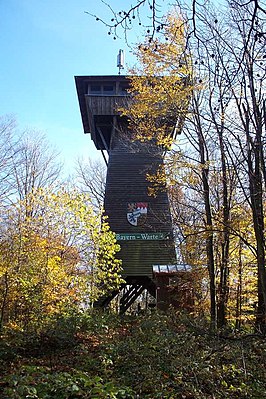
Bayernwarte on the Dieberg |
||
| height | 639 m above sea level NHN | |
| location | Bavaria , Germany | |
| Mountains | Cham-Further Valley | |
| Coordinates | 49 ° 19 '37 " N , 12 ° 52' 8" E | |
|
|
||
| particularities | Bayernwarte ( AT ) | |
The Dieberg ( 639 m above sea level ) is a mountain in Bavaria ( Germany ). It rises almost three kilometers northeast of the city center of Furth in the forest near the border with the Czech Republic in the Cham-Further Senke .
geography
The Dieberg forms the southernmost branch of the ridge that extends from the Spálený vrch ( Brennteberg , 668 m nm ) over the Špička ( Spitzberg , 601 m nm ) and forms the western end of the Cham-Further valley to the Upper Palatinate Forest . It is surrounded in the west by the valley of the Warm Pastritz , in the east by the valley of the Plassendorfer Bach and in the south by the valley of the Chamb with the Drachensee .
Surrounding places are Horní Folmava in the north, the deserted Kubička ( Plassendorf ) and Daberg in the northeast, Klöpflesberg and Ochsenweid in the east, Ösbühl in the southeast, Seuchau in the south, Furth in the forest in the southwest, Sauberg and Dieberg in the west and the deserted Ovčí Vrch ( Schafberg ) in the northwest.
history
Between 1974 and 1975, the Furth mountain rescue service had the 20-meter-high wooden observation tower “ Bayernwarte” built in the forest on the Dieberg . Between 2003 and 2005, the dam for the Drachensee was built at the southern foot of the mountain .

