Dieskaustraße
| Dieskaustraße | |
|---|---|
| Street in Leipzig | |
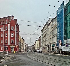
| Dieskaustraße in Kleinzschocher | |
| Basic data | |
| place | Leipzig |
| District | Kleinzschocher , Großzschocher , Windorf , Knautkleeberg , Knauthain |
| Connecting roads | Zschochersche Strasse, Knautnaundorfer Strasse |
| Cross streets | Antonienstraße, Wigandstraße, Neue Straße, Hirzelstraße, Altranstädter Straße, Creuzigerstraße, Rolf-Axen-Straße, Schwartzestraße, Kulkwitzer Straße, Pörstener Straße, Kötzschauer Straße, Windorfer Straße, Kurt-Kresse-Straße, Bismarckstraße, Arthur-Nagel-Straße, Albert- Vollsack-Strasse, Hornstrasse, Eichelbaumstrasse, Kunzestrasse, Brauereistrasse, Karl-Heft-Strasse, Anton-Zickmantel-Strasse, Huttenstrasse, Brückenstrasse, Gerhard-Ellrodt-Strasse, Zur Alten Bäckerei, Wingertgasse, Immenstrasse, Butterfly Trail, Ameisenstrasse, Seumestrasse, Schatzweg, Göhrenzer Strasse, Albersdorfer Strasse, Fortunabadstrasse, Emil-Teich-Strasse, Hohenthalstrasse, Gleitsmannstrasse, Schönbergstrasse, Rehbacher Strasse |
| Places | Schwartzeplatz, Martinsplatz |
| Buildings | Apostle Church (Leipzig-Großzschocher) |
| use | |
| User groups | Pedestrian traffic , bicycle traffic , car traffic , partially tram Leipzig |
| Technical specifications | |
| Street length | 6.5 km |
The Dieskau Street is an important transportation link in Leipzig Southwest.
location
Dieskaustraße begins as an extension of Zschocherschen Straße on the border with Plagwitz am Adler , the most important main road crossing in Leipzig's Kleinzschocher district . This street star still owes its name to the golden eagle sculpture that was on the gable of the Goldener Adler inn, which has been in existence since 1874 . The dilapidated building was demolished in 1994. To this day, the property in the acute angle between Windorfer and Dieskaustraße has remained undeveloped.
Dieskaustraße continues in a southerly direction through the districts of Kleinzschocher, Großzschocher , Windorf , Knautkleeberg to Knauthain , where it ends on Knautnaundorfer Straße.
history
The Dieskaustraße follows - like its northern connecting piece, the Zschochersche Straße - a medieval road connection that connected Lindenau with the villages to the south on the left bank of the White Elster . This probably originated in the second half of the 13th century, when the Knutones were the landlords of the villages Knauthain, Knautkleeberg and Knautnaundorf. With these they were enfeoffed by the bishops of Merseburg . In 1898 it was reported: "Plagwitzer Strasse seems to be the oldest street in the town, because we still have people in our part of town who can remember that their parents had to pay the pensions to Merseburg to the monastery" ( Grund- und House owners association Leipzig-Kleinzschocher :)
Today's Dieskaustraße was called “Lindenau-Knauthainer Straße” in 1879 in the “Road and Path Regulative for Kleinzschocher”. In the course of the industrialization of the areas west of Leipzig, a building plan for the construction of residential houses west of Plagwitzer Strasse was drawn up in 1876 . Due to the associated increase in the number of residents and the large number of commuters, the Kleinzschocher town council applied for a connection to the Leipzig tram network in 1886. This did not take place until 1896/97, after Kleinzschocher had been incorporated into Leipzig in 1890. In 1891 Plagwitzer Straße was widened from 17 to 21 meters.
Despite its considerable size, Dieskaustraße hardly achieved the status of a major arterial road like Koburger Straße, for example, as Leipzig's goods and trade traffic to the south was mostly east of the Elsteraue. With the new construction of the four-lane Bundesstraße 2 , the Dieskaustraße also lost its importance.
Street name
The Dieskaustraße got its current name after the von Dieskau family , who owned the manors Kleinzschocher, Großzschocher and Knauthain from the end of the 16th century to the end of the 17th century . A precise time of naming cannot be given, as the street had different names at different times in the individual suburbs. The name came up in Großzschocher in 1896 and in Kleinzschocher in 1904. With the naming of Zschocherschen Strasse in 1904, the northern section of the former Plagwiter Strasse was drawn from the Plagwitz district boundary (approximately at the level of Markranstädter Strasse) to the Adler to the new Zschocherschen Strasse, the southern part came to the existing Dieskaustrasse in Großzschocher.
From 1950 the Dieskaustraße was called Komsomol Street . The reason for this was, among other things, the enormous communist resistance in the south-west of Leipzig during the time of National Socialism . In 1933 there was an illegal KPD printing house in the “Reichsverweser” inn on Martinsplatz . The former commercial vocational school II was also named " Erika von Brockdorff " in 1985 .
In the course of reunification, it was renamed Dieskaustraße on January 1, 1992 .
traffic
There has been a tram line on Dieskaustraße since 1896 . Line 3 is currently running almost to the end of Dieskaustraße in Knauthain. There is also train traffic on the Leipzig – Gera – Saalfeld line , the stopping point of which is in Knauthain.
Development
Within Kleinzschocher, the architecture is still partly characterized by two-story rented houses, but mostly by Art Nouveau buildings and Wilhelminian style houses. In general, most of the houses along the entire Dieskaustraße have been renovated, but the proportion of renovated houses in the cross streets is considerably small. The oldest still existing house from the 18th century is in Dieskaustraße 77. Schwartzeplatz is also located on Dieskaustraße in Kleinzschocher. In 1835 this was created as a cemetery and existed as such until 1892. The former vocational school center 2, the Johannes-Kepler-Gymnasium and the 56th middle school are located on Dieskaustraße. Opposite the Johannes-Kepler-Gymnasium is the Martinsplatz, a small green area. At the intersection with Windorfer Straße is the Alfred-Rosch-Kampfbahn , a cycling track that is rarely used today. In Windorf, the Dieskaustraße runs along the Südwest Naturbad , a former gravel pit that extends as far as Knauthain. In 1996 construction work began on the modernly designed "Richard Wagner Gesamtwohnpark", which was finally completed in 1997.
Individual evidence
- ↑ In the Leipzig Elsterland. In the Leipzig Elsterland. Plagwitz, Schleußig, Kleinzschocher, Großzschocher, Windorf, Knautkleeberg, Knauthain, Hartmannsdorf. Pro Leipzig, Leipzig 1997, ISBN 3-9805368-3-1 , p. 114
- ↑ a b Gina Klank; Gernot Griebsch: Lexicon of Leipzig street names. Verlag im Wissenschaftszentrum Leipzig, Leipzig 1995, ISBN 3-930433-09-5 , p. 53 f.
literature
- Mustafa Haikal (Ed.): In the Leipziger Elsterland. Plagwitz, Schleußig, Kleinzschocher, Großzschocher, Windorf, Knautkleeberg, Knauthain, Hartmannsdorf . Pro Leipzig, Leipzig 1997, ISBN 3-9805368-3-1 .
- Gerhard Wolschke et al .: Leipzig-Southwest. From the history of a city district . First part. Council of the City District Leipzig-Southwest, Leipzig 1990.
Coordinates: 51 ° 17 ′ 38.5 " N , 12 ° 19 ′ 16.2" E


