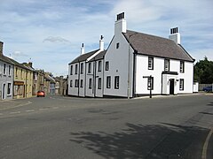
Douglas (South Lanarkshire)
|
Douglas Scottish Gaelic Dùghlas |
||
|---|---|---|
| Street train in Douglas | ||
| Coordinates | 55 ° 33 ′ N , 3 ° 51 ′ W | |
|
|
||
| Residents | 1620 2011 census | |
| administration | ||
| Post town | LANARK | |
| ZIP code section | ML11 | |
| prefix | 01555 | |
| Part of the country | Scotland | |
| Council area | South Lanarkshire | |
| British Parliament | Dumfriesshire, Clydesdale and Tweeddale | |
| Scottish Parliament | Clydesdale | |
Douglas ( Scottish Gaelic Dùghlas ) is a village in the center of the Scottish Council Area South Lanarkshire or in the traditional county of Lanarkshire . It is located around 17 kilometers southwest of Lanark and 38 kilometers east of Kilmarnock on the right bank of the Douglas Waters .
history
The village developed with Douglas Castle , the ancestral seat of the black line of the influential Clan Douglas and the Earls of Douglas . Douglas Castle is believed to date from the 13th century. A church on the site was mentioned as early as the 12th century. Today's St Bride's Church is believed to date from the late 14th century. The family crypt of the black Douglases is also located there.
In 1458, Douglas was installed as the Burgh of Barony . Considered the martyr of the Covenanters , tailor James Gavin is from Douglas. A memorial was erected in his memory. On the eastern edge of Douglas near the bank of Douglas Water, James Douglas, Earl of Angus, mustered the Cameronians in 1692 . The Earl of Angus' Monument is a reminder of this .
In the course of the centuries, coal was initially mined in Douglas, and later the textile industry settled. On the 469 m high Hagshaw Hill , which is five kilometers to the west, Scotland's first wind farm was built in 1994.
While 1426 people lived in Douglas in 1861, the number fell in the following decades to 1081 in 1891. In the course of the 1951 census survey, Douglas counted 2,263 inhabitants. After the population fell in 1991, only 1616 people lived in the village. Since then, the population has stagnated around this value.
traffic
The A70 ( Edinburgh - Ayr ) forms the main thoroughfare from Douglas and connects the village directly to the trunk road network. About three kilometers to the east there is a connection to the M74 motorway , which is part of the European route 5 on this section .
Individual evidence
- ^ Information from the Scottish Parliament
- ↑ a b c d Entry in the Gazetteer for Scotland
- ↑ Listed Building - Entry . In: Historic Scotland .
- ↑ Information from the Scottland's Churches Trust
- ↑ Listed Building - Entry . In: Historic Scotland .
- ^ Entry in the Gazetteer for Scotland
- ^ Information in the Gazetteer for Scotland
- ↑ 2011 census data

