Douglastown (Angus)
| Douglastown | ||
|---|---|---|
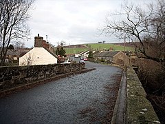
| Street train in Douglastown | ||
| Coordinates | 56 ° 37 ′ N , 2 ° 57 ′ W | |
|
|
||
| administration | ||
| Post town | FORFAR | |
| ZIP code section | DD8 | |
| prefix | 01307 | |
| Part of the country | Scotland | |
| Council area | Angus | |
| British Parliament | Angus | |
| Scottish Parliament | Angus South | |
Douglastown is a town in the Scottish Council Area Angus and the traditional Scottish county of Forfarshire. It is located about 36 km northeast of Perth and about 16 km north of Dundee at the foot of the Sidlaw Hills . The nearest town is Forfar, four kilometers to the northeast . The stream Kerbet Water runs along the western outskirts and flows two kilometers to the north into Dean Water .
Douglastown developed around a flax mill founded in 1792. This was operated by the mathematician James Ivory . At the end of the 19th century, the Parish School was located in Douglastown.
traffic
Douglastown is just off the A94 which connects Perth to Forfar . In Douglastown, the B9127 coming from Arbroath joins the A94. With the airports of Perth and Dundee are two airports within a radius of 30 km.
Individual evidence
- ↑ a b Douglastown. Angus. In: David Munro, Bruce Gittings: Scotland. An Encyclopedia of Places & Landscapes. Collins et al., Glasgow 2006, ISBN 0-00-472466-6 .
- ^ Douglastown. In: Francis H. Groome: Ordnance Gazetteer of Scotland: A Survey of Scottish Topography, Statistical, Biographical and Historical. Volume 2: (Cor - Edn). Thomas C. Jack, Grange Publishing Works, Edinburgh et al. 1884, p. 367 .

