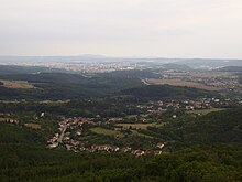
Drahan mountain country

The Drahaner Uplands (Czech Drahanská vrchovina ) is the highest part of the Brno Uplands ( Brněnská vrchovina ) in the Czech Republic . It is located in Central Moravia .
geography
The mountainous area has an area of 1,183 km² and an average height of 462.8 m above sea level. M. The highest elevation is 735 m above sea level. M. the Skalky located in the Konická vrchovina . Geomorphological sub-units are the Adamovská vrchovina and the Konická vrchovina as well as the Moravian Karst , which is the best known for its caves and sinkholes .
Towards the west, the Drahaner Bergland falls into the Boskowitz furrow and to the southwest it merges into the Bobravská vrchovina . The Thaya-Schwarza valley basin and the Wischauer Tor ( Vyškovská brána ) extend south . The Upper Moravian Basin ( Hornomoravský úval ) , known as Hanna , connects to the east . To the north there is a smooth transition to the Hohenstädter Uplands ( Zábřežská vrchovina ). The rivers Haná and Hloučela have their source in the Drahaner Bergland .
A large part of the forests in the mountain region belongs to the Březina military training area ( Vojenský újezd Březina ), which was created from the former Wischau ( Vyškov ) military training area of the Wehrmacht from 1940.
history
The Drahaner Bergland was only sparsely populated until the 12th century. The main colonization of the mountainous landscape was carried out by the Diocese of Olomouc and the rule of Hohlenstein . The founders of the new villages were mostly German settlers. Already in the 14th century the area began to decline due to military campaigns; During this time as well as during the Hussite Wars, numerous villages became extinct. The inhabitants of the region lived primarily from logging, charcoal burning and pitch production. Home weaving was added later. After the German occupation, the decision was made in 1941 to expand the Wischau military training area into a Wehrmacht training area. In the process, 33 villages were dissolved and mostly ruined by 1945. After the end of the war, the villages were repopulated; in 1951, most of these communities had to cede their forests to the military.
