Drilandsee
| Drilandsee | ||
|---|---|---|

|
||
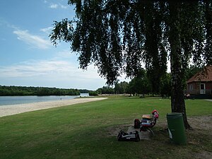
| View of the bathing beach of the Drilandsee | ||
| Geographical location | District of Borken , North Rhine-Westphalia | |
| Places on the shore | Gronau | |
| Location close to the shore | Gronau , Overdinkel , Enschede | |
| Data | ||
| Coordinates | 52 ° 14 '24 " N , 7 ° 4' 42" E | |
|
|
||
| surface | 28 ha | |
| length | 1.1 km | |
| width | 400 m | |
| scope | 3.3 km | |
| Maximum depth | 7 m | |
| Middle deep | 4 m | |
The Drilandsee (also Dreiländersee or Driländer) is a body of water north of Gronau in the Borken district ( North Rhine-Westphalia ).
Surname
The name is based on the centuries-old field name Driland ("dri" = three), which was recorded on maps around 1865, and refers to the meeting of Westphalia , the former county of Bentheim and the Dutch province of Overijssel .
description
The Drilandsee is an artificially created lake in the 1980s to enhance the region's leisure activities. Restaurants, campsites and holiday homes have been built in the immediate vicinity . The optically striking division into two separates the bathing and swimming area from the water sports area. The greater part of the lake is open to surfers, sailors, rowers and anglers. An easily accessible path of approx. 3.3 km in length leads around the lake. The border between North Rhine-Westphalia and Lower Saxony runs a few meters north of the lake, the border between Germany and the Netherlands about 200 meters west.
freetime and recreation
There is a wide sandy beach and a small island in the bathing and swimming area. The island can be reached on foot via very shallow water. Several play equipment provide entertainment for the younger visitors.
There is a pedal boat rental and a mini golf course on the larger area. The local water sports clubs use the lake for their own purposes and offer water sports.
As part of the 8 lakes community, an "8 lakes regatta" takes place once a year. Up to 45 sports boaters from the surrounding water sports clubs go on two days on the lake.
See also
List of lakes in North Rhine-Westphalia
Web links
- Landschaftsverband Westfalen-Lippe: Dreiländersee in LWL geodata culture
Individual evidence
- ↑ Hanspeter Dickel et al .: Nature and culture of the Gronau and Epe area. Volksbank eG Gronau, Gronau in Westphalia 1982. OCLC 63507159 , Annex Atlas p. 21.
- ↑ Geodata Atlas - Historical Map of Gronau. In: maps.kreis-borken.de. Retrieved February 22, 2016 .
- ↑ Watersports Department Vorwärts Gronau - segeln-gronau.de , accessed on January 6, 2017
- ↑ Clubs of the 8 Lakes Regatta: 8 Lakes Regatta . Retrieved August 25, 2015.

