Drosedower Bek
| Drosedower Bek | ||
|
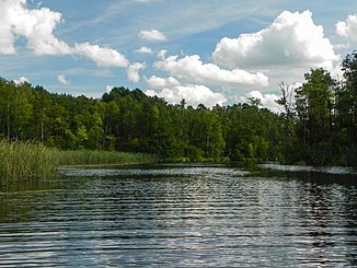
The Drosedower Bek between Rätzsee and Gobenowsee |
||
| Data | ||
| Water code | DE : 581166 | |
| location | Germany , Mecklenburg-Western Pomerania | |
| River system | Elbe | |
| Drain over | Dollbek → Müritz-Havel-Wasserstraße → Havel → Elbe → North Sea | |
| origin |
Rätzsee 53 ° 14 ′ 57 ″ N , 12 ° 54 ′ 24 ″ E |
|
| muzzle |
Gobenowsee coordinates: 53 ° 13 ′ 54 " N , 12 ° 54 ′ 46" E 53 ° 13 ′ 54 " N , 12 ° 54 ′ 46" E |
|
| Mouth height | 57.4 m | |
| Height difference | <0.1 m | |
| Bottom slope | <0.04 ‰ | |
| length | 2.6 km | |
| Catchment area | 70 ha | |
| Communities | Wustrow (Mecklenburg Lake District) , municipality of Mirow | |
The Drosedower Bek ( Low German: Drosedower Bach ) is a river in the Mecklenburg Lake District in the Mecklenburg Lake District in Mecklenburg-Western Pomerania . It connects the Rätzsee with the Gobenowsee and thus belongs to the more extensive river system of the Upper Havel .
The Drosedower Bek leaves the Rätzsee in its northern part, flows at a very low flow speed (less than 0.1 meter difference in altitude over 2.5 kilometers) about 0.5 km west of the village of Drosedow , and flows into the northern part of the Gobenowsee. There are alder swamps and swamps on both sides along the entire course of the river . The water is closed to motorized boat traffic.
