Rätzsee
| Rätzsee | ||
|---|---|---|

|
||
| Rätzsee | ||
| Geographical location | District of Mecklenburg Lake District | |
| Tributaries | Müritz-Havel waterway across the Oberbek | |
| Drain | Drosedower Bek | |
| Places on the shore | no | |
| Data | ||
| Coordinates | 53 ° 14 '30 " N , 12 ° 53' 13" E | |
|
|
||
| Altitude above sea level | 57.5 m above sea level NHN | |
| surface | 2.92 km² | |
| Maximum depth | 20 m | |
The Rätzsee is located in the Mecklenburg Lake District, southeast of Mirow and southwest of Neustrelitz in southern Mecklenburg-Western Pomerania , near the border with Brandenburg . It lies entirely in the Mirow urban area. It is 5.5 kilometers long and up to 750 meters wide.
There is a runoff to the east Gobenowsee via the Drosedower Bek , which leaves the lake in the northeast and flows south. In the south, the Rätzsee flows from the Vilzsee to the Oberbek . On the swampy north bank, a ditch connects the water with the Zirtowsee .
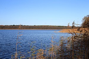
The banks are almost completely wooded and mostly covered with reeds. There are tent sites in the north-east and south-west. The lake is closed to motor boats.
