Dundonald (South Ayrshire)
|
Dundonald Scottish Gaelic Dùn Dòmhnaill |
||
|---|---|---|
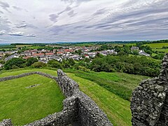
| Dundonald seen from the castle | ||
| Coordinates | 55 ° 35 ′ N , 4 ° 36 ′ W | |
|
|
||
| Residents | 2652 (2011 census) | |
| administration | ||
| Post town | KILMARNOCK | |
| ZIP code section | KA2 | |
| prefix | 01563 | |
| Part of the country | Scotland | |
| Council area | South Ayrshire | |
| British Parliament | Central Ayrshire | |
| Scottish Parliament | Carrick, Cumnock and Doon Valley | |
Dundonald is a village in the Scottish council area of South Ayrshire . It is in the north of the region between the towns of Troon and Kilmarnock , which is already in East Ayrshire . The Irvine runs around 1.5 km to the north .
history
Dundonald's early history is closely linked to Dundonald Castle . This dates from the 12th century and was one of the possessions of the House of Stuart . It was the seat of King Robert II , who also died there, and various princes of the ruling dynasty. The fortress was abandoned in the 16th century. Under William Cochrane, 1st Earl of Dundonald , the construction of the manor house to the west of Auchans Castle began in the 1640s , which was probably abandoned around 1780 and is also only preserved today as a ruin. With the Fairlie House built around 1800 for William Cuninghame-Fairlie, 6th Baronet , another mansion was added.
While coal mining and weaving were important occupations in the past centuries, Dundonald is more associated with nylon production and quarries in modern times . Before World War II , a military camp known as Dundonald Camp was located west of the village. This was in connection with the air force base RAF Dundonald . The buildings of Dundonald Camp are now used as an industrial park.
While the population of the village between 1871 and 1891 fell from 1507 to 1166, in 1961 there were already 1293 people in Dundonald. In the period that followed, the number of inhabitants increased, so that the last 2652 inhabitants were counted in 2011.
traffic
In Dundonald the B730 crosses the A759 (Kilmarnock – Troon). Both roads connect the village to the A71 in the north, the A77 in the southeast and the A78 in the west. With Glasgow Prestwick Airport , an international airport is located around eight kilometers to the southwest.
Individual evidence
- ↑ a b c Entry in the Gazetteer for Scotland
- ↑ Entry on Dundonald Castle in Canmore, the database of Historic Environment Scotland (English)
- ↑ Entry on Auchans House in Canmore, the database of Historic Environment Scotland (English)
- ↑ Listed Building - Entry . In: Historic Scotland .
- ^ Information in the Gazetteer for Scotland
- ^ Information in the Gazetteer for Scotland
- ↑ 2011 census

