EastLink
| EastLink | |
|---|---|

|
|
| Basic data | |
| Operator: | VicRoads |
| Start of the street: |
M3 Eastern Freeway Donvale ( Melbourne ) ( VIC ) ( 37 ° 48 ′ S , 145 ° 11 ′ E ) |
| End of street: |
|
| Overall length: | 39 km |
|
States : |
|
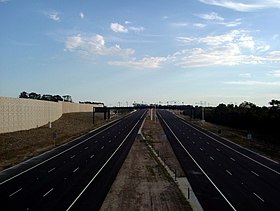
| EastLink heading south from the pedestrian overpass on Koomba Road (before opening) | |
The EastLink is an urban motorway in Melbourne in the south of the Australian state of Victoria . It connects the Eastern Freeway in Donvale through the eastern and southern suburbs of the city with the Frankston Freeway in Carrum Downs . Use is subject to a toll. It is part of the Melbourne ring road system .
history
In the Melbourne Transportation Plan of 1969, the planned road can be found as Freeway Corridor F35.
This motorway connection was discussed again and again: one side cited the advantages of a complete motorway ring around Melbourne, the other the environmental damage to be expected as a result. In October 1999, the Bracks administration announced that the plans for the motorway - which the Labor government had not promised in the election campaign - had been canceled. Instead, a railway line should be built to Rowville and tram line 75 extended to Knox . However, none of this was realized. In August 2000, the same government announced that it was trying to obtain federal grants to build the highway. For this, the road had to be classified as a "road link of national importance", although it was not to become part of the national highway network. The complete turnaround by the government was heavily criticized by organizations like the Public Transport Users Association as it meant that the Rowville railroad project was again canceled. In 2001, Paul Mees , a graduate of the University of Melbourne , filed a lawsuit against Transport Minister Peter Batchelor and VicRoads for an environmental offense in the Federal Court of Justice. The authorities should be forbidden to " initiate any future measures to build the Scorseby Freeway or the Eastern Ring Road ". He stated the highway would disrupt migratory birds, eradicate plant species, and destroy wetlands. The motorway should also be part of a further plan for a ring road to Greensborough . Due to the pending proceedings, the motorway ring was removed from the draft strategy paper.
In 2003 the Southern and Eastern Integrated Transport Authority (SEITA) was established by the state government of Victoria. She was supposed to oversee the project for the government and carry out tendering and awarding.
In October 2004, SEITA awarded the contract for the planning, construction and operation of the EastLink to ConnectEast , a company that was listed in the ASX in November 2004 . ConnectEast in turn commissioned Thiess-John Holland , a joint venture between two large construction companies, with the detailed planning and construction of the EastLink.
ConnectEast has been responsible for running the road for 39 years. Construction of the EastLink began in March 2005, and the road opened on June 29, 2008.
After the new connection opened on June 29, 2008, traffic on the neighboring Stud Road, Springvale Road and Blackburn Road decreased by 30 to 40%, but traffic on the Eastern Highway increased by 5% at the junction with Burke Road and by 1 to 2% on Hoddle Street in downtown. An average of 270,686 vehicles use this road every day and tolls have been levied since July 23, 2008. In the first week of toll collection, the daily traffic volume fell to 133,722 vehicles. This was within the expected 40 to 50% reduction, but 1/3 below the predicted figures. The average toll per trip is AU $ 3.10, more than the predicted AU $ 2.91.
In the first six months of operation, the EastLink generated a loss of almost AU $ 93 million. In 2010 the road had already amortized, although the traffic volume expected by experts had to be revised downwards.
Name story
There have been many names for the project over the years: Eastern Ring Road, Scoresby Freeway, Scoresby Bypass and Mitcham Frankston Freeway .
On March 23, 2005, when construction began, the then Prime Minister of Victoria, Steve Bracks , announced that the new street would be called EastLink .
On February 27, 2008 it was announced that the connection of the EastLink to the Monash Freeway Tom Wills Interchange - after the inventor of Australian football - will be named. On March 24, 2008, Tim Pallas announced that the two parallel tunnels would be called Melba and Mullum Mullum .
course
The EastLink begins at the eastern end of the Eastern Freeway (M3) on Springvale Road in Nunawading and tunnels under the suburb of Ringwood and Mullum Mullum Creek . It then heads about 40 km south towards Frankston , passing through the suburbs of Wantirna, Wantirna South, Scoresby, Rowville, Mulgrave, Dandenong North, Noble Park, Keysborough, Dandenong South, Bangholme and Carrum Downs . It ends at the north end of the Frankston Freeway (S11).
Most of the freeway has six lanes, only four lanes between Thompson Road and Frankston Freeway.
Crossings and junctions
|
EastLink |
|||
| Connections to the north | Distance to Melbourne about (km) |
Distance to Frankston (km) |
Connections to the south |
|
End of EastLink further as Eastern Freeway to Melbourne |
22nd | 44 |
Start of EastLink from the Eastern Freeway |
| Nunawading, Donvale Springvale Road |
|||
| MELBA TUNNEL | - | - | MULLUM MULLUM TUNNEL |
| Ringwood, Mount Dandenong Ringwood Bypass |
27 | 39 | Ringwood, Mount Dandenong Ringwood Bypass |
| Nunawading, Box Hill (only left turns) Maroondah Highway |
Ringwood, Box Hill Maroondah Highway |
||
| RAILWAY LINE TO BELGRAVE RAILWAY LINE TO LILYDALE |
RAILWAY LINE TO BELGRAVE RAILWAY LINE TO LILYDALE |
||
| Forest Hill, Heathmont Canterbury Road |
29 | 37 | Heathmont, Forest Hill Canterbury Road |
| Mitcham, Wantirna Boronia Road |
31 | 35 | Wantirna, Mitcham Boronia Road |
| Burwood, Belgrave Burwood Highway |
33 | 33 |
Belgrave , Burwood Burwood Highway |
| Glen Waverley, Wantirna South High Street Road |
35 | 31 | Wantirna South, Glen Waverley High Street Road |
| Oakleigh, Scoresby Ferntree Gully Road |
38 | 28 | Scoresby, Oakleigh Ferntree Gully Road |
| BP SERVICE CENTER |
39 | 27 | BP SERVICE CENTER under construction |
| Mulgrave, Rowville Wellington Road |
40 | 26th | Rowville, Mulgrave Wellington Road |
| no exit | 42 | 24 | Dandenong North, Springvale Police Road |
| Connections to the north | Distance to Melbourne about (km) |
Distance to Frankston (km) |
Connections to the south |
| Springvale, Dandenong North Police Road |
29 | 23 | TOM WILLS INTERCHANGE Warragul , Traralgon , Melbourne Monash Freeway |
| TOM WILLS INTERCHANGE Chadstone, Melbourne Monash Freeway |
|||
| Oakleigh, Dandenong Princes Highway |
31 | 21st |
Dandenong , Oakleigh Princes Highway |
| RAILWAY LINE TO GIPPSLAND METROLINIEN TO PAKENHAM AND CRANBOURNE |
33 | 19th | RAILWAY LINE TO GIPPSLAND METROLINIEN TO PAKENHAM AND CRANBOURNE |
| no exit | 34 | 18th |
Dandenong , Mentone Cheltenham Road |
| Keysborough, Dandenong Dandenong Bypass |
36 | 16 |
Dandenong , Keysborough Dandenong Bypass |
|
Mordialloc , Narre Warren Greens Road |
38 | 14th | Fool Warren, Mordialloc Greens Road |
| Carrum, Cranbourne Thompson Road |
44 | 8th | Cranbourne, Carrum Thompson Road |
|
Start EastLink on from Frankston Freeway |
47 | 5 | Flinders, Portsea Peninsula Link under construction |
|
Carrum Downs , Cranbourne Rutherford Road |
|||
|
At the end of EastLink, continue as Frankston Freeway to Frankston / Portsea |
|||
Dandenong bypass
A three-mile stretch of the Dingley Freeway called Dandenong Bypass was built by ConnectEast and Thiess-John Halland as part of the EastLink project. The bypass was opened on December 9, 2007.
Web links
- Official website of the EastLink. ConnectEast (English)
- Website of Connect East (English)
- Website of the SEITA (English)
- The SICE website (English)
- EastLink Flyover Video of a flyover over the EastLink. Herald Sun
- Online report on the project. ABC (English)
- Statement by Justice Gray on the likelihood that the Scoresby Freeway could be a catalyst for further Freeway projects in environmentally sensitive areas (English)
literature
- Steve Parish: Australian Touring Atlas . Steve Parish Publishing. Archerfield QLD 2007. ISBN 978-1-74193-232-4 . P. 41
Individual evidence
- ^ About Eastlink . Southern and Eastern Integrated Transport Authority. Archived from the original on June 25, 2008. Retrieved June 26, 2008.
- ↑ Sushi Das: $ 786m Freeway Link Scrapped , The Age. October 28, 1999, p. 6.
- ^ Sushi Das: Scoresby Freeway Back On Agenda , The Age. August 8, 2000, p. 3.
- ↑ Sushi Das: Anger At U-turn On Scoresby Freeway , The Age. August 21, 2000, p. 3.
- ^ Andrew Heasley: Scoresby Freeway Faces Hurdle , The Age. October 27, 2001, p. 13.
- ^ Andrew Heasley: Ring road plan altered before case . The Age. S. 6. October 31, 2002. Retrieved July 20, 2012.
- ↑ a b Who's involved? . Southern and Eastern Integrated Transport Authority. Archived from the original on June 1, 2008. Retrieved June 26, 2008.
- ^ Julia Milesi: No delays as EastLink tollway cuts traffic . In: The Ague . www.theage.com.au. June 30, 2008. Retrieved August 17, 2008.
- ^ A b John Beveridge: Road fees take a toll . In: Herald Sun , www.news.com.au, August 8, 2008. Retrieved August 17, 2008.
- ^ Mathew Murphy: EastLink owner optimistic despite loss . In: The Age . Fairfax. February 26, 2009. Retrieved October 23, 2010.
- ↑ Simon Santow: Tolls cut as motorists run from costly roads . In: ABC . abc.net.au. June 29, 2010. Retrieved October 24, 2010.
- ^ Dan Silkstone: Naming and Blaming Launches Tollway . The Age, March 24, 2005. p. 10
- ^ EastLink interchange honors one of football's founders EastLink Interchange honors one of football's founders . SEITA, February 27, 2008. Retrieved on March 26, 2008 ( Memento of the original from September 5, 2009 in the Internet Archive ) Info: The archive link was inserted automatically and has not yet been checked. Please check the original and archive link according to the instructions and then remove this notice.
- ^ Georgie Pilcher: East Link Twin Tunnels named as Melba and Mullum Mullum . In: Herald Sun . March 24, 2008. Retrieved July 20, 2012.
- ↑ East Link Map (Melway) (PDF): Melway . Melway Publishing. Retrieved June 26, 2008.
- ^ EastLink facts and figures . Southern and Eastern Integrated Transport Authority. Archived from the original on June 1, 2008. Retrieved June 26, 2008.
- ↑ Dandenong Bypass . Southern and Eastern Integrated Transport Authority. Archived from the original on July 19, 2008. Retrieved June 26, 2008.
- ↑ Eastlink tollway to open six months early . Herald Sun, December 10, 2007. Retrieved December 12, 2007.


