Einsiedel (Masserberg)
|
Einsiedel
community Masserberg
Coordinates: 50 ° 29 ′ 28 ″ N , 10 ° 54 ′ 39 ″ E
|
|
|---|---|
| Height : | 515 m |
| Residents : | 101 (Dec. 31, 2013) |
| Incorporation : | April 1, 1974 |
| Incorporated into: | Heubach |
| Postal code : | 98666 |
| Area code : | 036870 |
|
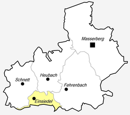
Location of Einsiedel in Masserberg
|
|
Einsiedel is a district of Masserberg in the Hildburghausen district in Thuringia .
location
Einsiedel is 530-550 meters above sea level on the middle course of the Biber on the south-western slope of the Thuringian Forest . Einsiedel was once on the trade route to or from Nuremberg .
history
On January 1, 1307, the place was first mentioned in a document. The village proves 1597. In 1853 there were twelve houses with 16 families and 72 people in the village. They had 30 head of cattle. There was an inn, a grinder and two cutting mills. There was poverty. In 1800 the wooden bell tower was built. There was a school in 1912. In 1974/75 it was incorporated into Heubach . In 1997, Heubach and Einsiedel became part of the Masserberg unified community. Einsiedel has only been an independent district of Masserberg since 2001. At the end of 2013, 101 residents lived in the district. The number of holiday guests is increasing.
Individual evidence
- ↑ www.insuedthueringen.de, January 14, 2014
- ^ Wolfgang Kahl : First mention of Thuringian towns and villages. A manual. Rockstuhl Verlag, Bad Langensalza, 2010, ISBN 978-3-86777-202-0 , p. 66
- ↑ The location on the municipality's website ( memento of the original from January 28, 2017 in the Internet Archive ) Info: The archive link was automatically inserted and not yet checked. Please check the original and archive link according to the instructions and then remove this notice. Retrieved January 28, 2017


